Imagine a small coastal community at the periphery of a tropical storm. Hours before the first waves hit, an antenna smaller than a dinner plate begins detecting subtle changes in signal patterns from satellites thousands of kilometres overhead. Within minutes those changes reveal that the tide is rising far faster than normal. A sign of a storm surge. Warnings are issued and lives are saved. This is the power of Global Navigation Satellite Systems (GNSS) when used not only for navigation but as a tool for environmental sensing (Li et al. 2024).
By enabling early warnings, safer cities and better management of water and marine resources, GNSS also helps advance global goals such as ensuring access to clean water (SDG 6 - Clean Water and Sanitation), building resilient communities (SDG 11 - Sustainable Cities and Communities), tackling climate change (SDG 13 - Climate Action) or protecting life below water (SDG 14 - Life Below Water).
1. From maps to water: What is GNSS?
“Global navigation satellite system (GNSS) is a general term describing any satellite constellation that provides positioning, navigation, and timing (PNT) services on a global or regional basis.” (NOAA 2025)
These constellations include the Global Positioning System (GPS, United States), European Satellite Navigation System (Galileo), the GLObal NAvigation Satellite System (GLONASS, Russian Federation), the BeiDou Navigation Satellite System (BDS, China), the Indian Regional Navigation Satellite System/ Navigation with Indian Constellation (IRNSS/NavIC, India) and Quasi-Zenith Satellite System (QZSS, Japan) (United Nations Office for Outer Space Affairs (UNOOSA) 2023b, UNOOSA 2025).
GNSS differ in how their constellations are designed and where their satellites orbit. GPS uses 24 slots across six medium Earth orbit (MEO) planes at about 20,000 kilometres altitude with up to 31 satellites operational. GLONASS also operates in MEO with 24 satellites arranged in three planes at around 19,100 kilometres altitude and a higher orbital inclination of 64.8 degrees. This improves coverage at northern latitudes. Galileo has a nominal constellation of 24 satellites plus six spares, evenly distributed in three MEO planes at 23,000 kilometres m altitude and 56 degree inclination. BeiDou is a hybrid system of 35 satellites. Five satellites orbit in geostationary orbit (GEO) at 35,786 kilometres, five in inclined geosynchronous orbit (IGSO) also at 35,786 kilometres with 55 degree inclination and 24 in MEO at 21,528 kilometres. IRNSS/NavIC, on the other hand, is a regional system of seven satellites, three in GEO and four in IGSO with a 29 degree inclination, covering India and surrounding areas. The QZSS complements GPS over Asia-Oceania with three satellites in inclined “quasi-zenith” orbits at 42,000 kilometres plus one GEO satellite (UNOOSA 2016).
While most people know GNSS as the technology behind smartphone maps or car navigation systems, these satellite signals carry much more than location data. The way GNSS signals are reflected off water surfaces, bent as they pass through the atmosphere or delayed on their way to Earth can be turned into measurements of water levels, wave heights, atmospheric moisture or snow water content. Their signals find direct use in scientific research (sea level rise, polar ice, soil moisture, etc.) and operational sectors (fisheries, aquaculture, hydropower or ports).
1.1. How GNSS works for water monitoring
GNSS satellites transmit signals primarily in the L-band of the radio spectrum around one to two gigahertz (GHz), as shown in Figure 1.
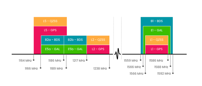
This frequency range is chosen for its ability to penetrate clouds, rain and vegetation with little loss of signal strength. Each signal consists of a pseudorandom code for ranging, navigation data with ephemerides, clock corrections and a carrier wave. By measuring the travel time of these signals from at least four satellites and applying corrections for atmospheric delays and other errors, GNSS receivers achieve accuracy ranging from meters to centimetres. With advanced processing like Precise Point Positioning (PPP) or Real-Time Kinematic (RTK), accuracy improves to millimetres. Any deviation from those predicted paths, whether by reflection off a surface, bending in the atmosphere, or delay through water vapour, encodes environmental information. Processing these variations allows retrieval of water-related parameters.
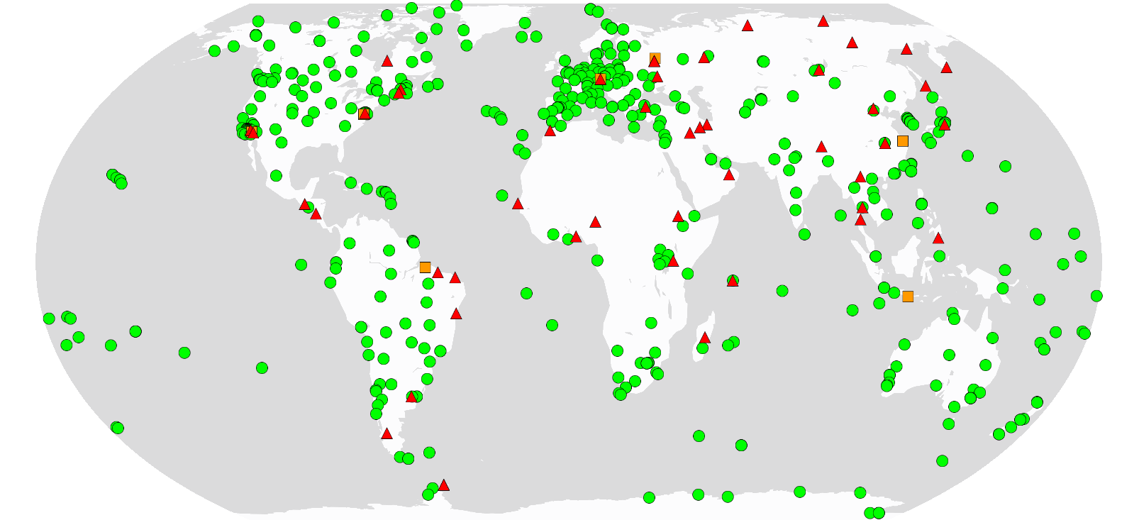
GNSS relies on measuring travel time of satellite signals to determine precise position on Earth. To achieve this, accurate satellite orbit and clock data are essential. Providing and coordinating these products, along with an open archive of GNSS observations, is the role of the International GNSS Service (IGS). The IGS is a global voluntary collaboration of more than 350 organisations in 118 countries, operating 529 permanent tracking stations as of 12 August 2025 (IGS 2025). Since 1994, the IGS has offered free, reliable access to GNSS data and products. All products are aligned with the International Terrestrial Reference System (ITRS), ensuring that positions from any location are expressed in a single, stable global coordinate system. This alignment is essential for comparing data collected at different sites and times without spatial or temporal inconsistencies. Figure 2 shows the network of ground stations that are currently operating.
Beyond standard positioning, there are specialized methods that use GNSS signals to study water and related environmental processes. These methods are outlined in the following sections.
2. Applications of GNSS in water science
2.1.GNSS positioning and hydrogeodesy
When large amounts of water accumulate on land, whether in rivers, lakes, snowpacks or underground aquifers, the added weight pushes the crust of Earth downward. When that water is lost, the crust slowly rebounds. Although these movements are only a few millimetres, permanent GNSS stations anchored to stable ground are sensitive enough to detect them (White et al. 2022).
By interpreting these deformations, scientists can estimate how much water is being stored or released across a landscape. This approach, known as GNSS hydrogeodesy, has become an important tool in hydrology and water resource management. For example, researchers have used it to monitor seasonal flooding in the Amazon Basin (Michael Bevis et al. 2005) and to study water-level variations in the Great Lakes (Argus et al. 2014). In Japan, GNSS hydrogeodesy observations have been applied to measure snowpack depth (Heki 2001) while in the Central Valley of California, they revealed how over-pumping of groundwater led to widespread land subsidence (Amos et al. 2014). GNSS hydrogeodesy has even captured rapid displacements linked to tsunamis (Larson et al. 2021a) and has been applied in studies of ocean and coastal loading at tide-gauge sites (Williams and Penna 2011). In Antarctica, a Canadian-led expedition used GNSS integrated with sonar to map underwater seafloor beneath ice shelves (GPS World 2025). Similarly, researchers in Greenland deploy GNSS stations to track ice sheet movement and ice mass loss, providing data for global sea level rise projections (Inside GNSS 2024).
Beyond research, the User Needs and Requirement Report on Energy and Raw Materials by the European Union Agency for the Space Programme (EUSPA) from 2024 shows hydropower operators using GNSS to support hydrological modelling, rainfall runoff analysis, reservoir operations and climate impact assessments, making hydrogeodesy a tool for both science and infrastructure planning (EUSPA 2024b).
2.1.1. GNSS Reflectometry (GNSS-R)
Global Navigation Satellite System Reflectometry (GNSS-R) is a passive remote sensing technique that makes use of both, the direct signal transmitted by a GNSS satellite and the same signal after it has reflected from a surface. The physical properties of the reflecting surface, such as its roughness, dielectric constant and moisture content, influence the way the signal is reflected. By analysing the reflected signal in comparison to the direct signal it is possible to extract quantitative information about the surface (Jin et al. 2024, Yu et al. 2022). GNSS-R can be carried out from the ground, from aircraft or from space as shown in Figure 3.
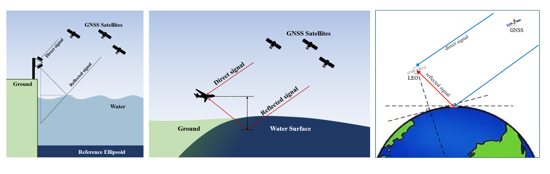
On the ground, a single antenna captures both, direct and reflected signals, producing interference patterns that reveal surface height (Larson and Williams 2023). Airborne and spaceborne systems usually employ separate antennas which allow the creation of delay Doppler maps. These maps record how signals spread in time and frequency. Their shape is influenced by the height and roughness of the sensed surface on Earth surface (Jin et al. 2024). An exemplary delay Doppler map is shown in Figure 4.
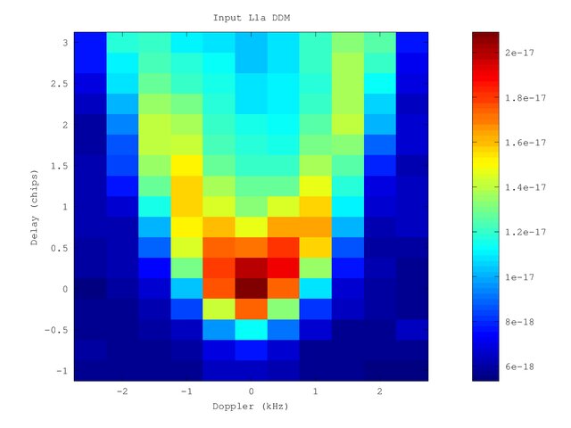
The bright red spot in Figure 4 near zero delay and Doppler is the specular reflection point where most of the GNSS signal bounced directly off the surface. The surrounding V-shaped spread in yellow and blue shows how surface roughness scatters the signal in both, delay and Doppler. Calibrated models derive these observables obtained in the delay Doppler map by linking the scattering characteristics of the reflected signal to specific wave height and surface wind speed.
GNSS-R has been applied to water level measurements in coasts, rivers and reservoirs. Tabibi and Francis (2020) demonstrated detection of rapid water-level shifts while Larson and Williams (2023) showed long term coastal monitoring. It can retrieve wave height and direction from surface roughness effects on the reflected signal, as shown above (Reinking, Roggenbuck, and Even-Tzur 2019). GNSS-R is also sensitive to snow depth and ice surface elevation changes which have been used to study glacier mass balance and accumulation variability (Siegfried et al. 2017).
Additionally, several space missions have demonstrated the power of GNSS-R. TechDemoSat-1 (2014) uses delay Doppler mapping from GPS L1 and L2 reflections for ocean altimetry (M. Unwin et al. 2016). The Cyclone GNSS (CYGNSS) constellation (2016) uses GNSS-R to monitor winds inside tropical storms, (“CYGNSS - NASA Science” 2025). The Mistrale H2020 project demonstrated GNSS-R for soil moisture, flooding and waterlogging maps, supporting agriculture and flood risk management. While the Oceanpal instrument allows to monitor waves, water level and winds with applications for coastal safety and climate research (UNOOSA 2018).
In New Zealand the Rongowai mission uses a CYGNSS receiver mounted on a passenger aircraft to track floods, coastal inundation and soil moisture (“Rongowai Science Payloads Centre” 2025). The CubeSat Assessment and Test (3CAT-2), a six unit (6U) CubeSat launched in 2016, tests a GNSS-R payload called P(Y) and C/A ReflectOmeter (PYCARO) which is capable to perform ocean altimetry, soil moisture and biomass monitoring (Carreno-Luengo et al. 2013). The upcoming HydroGNSS mission is expected to monitor soil moisture, inundations and permafrost (“HydroGNSS - Earth Online” 2025).
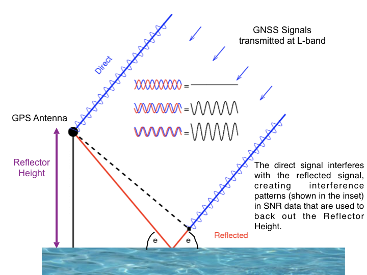
2.1.2. GNSS Interferometric Reflectometry (GNSS-IR)
GNSS Interferometric Reflectometry (GNSS-IR) is a specialized type of GNSS-R that focuses on the interference patterns created by the direct and the reflected signals. This technique uses an antenna on the ground, typically mounted near a shoreline, riverbank, lake edge or tide gauge. The direct and reflected signals are configured to interfere at the position of the antenna and produce an oscillation in the recorded signal-to-noise ratio, as shown in Figure 5.
This method has proven especially valuable for monitoring local height measurements. Studies have shown that GNSS-IR stations can detect sudden sea-level changes during tsunamis (Li et al. 2024, Larson et al. 2021). While traditional systems rely on deep-ocean buoys or seafloor pressure sensors GNSS-IR uses fixed coastal antennas to detect sudden water-level changes as tsunami waves approach shore. Li et al. (2024) demonstrated that island-based GNSS-IR networks could provide continuous, real-time tsunami monitoring. In fact, during the 2021 Gisborne earthquake in New Zealand, GNSS stations detected crustal displacements within minutes. This provided confirmation of the potential of the earthquake to generate a tsunami. The team of researchers that detected the signals are working on a tsunami early warning system (NASA Applied Sciences 2025).
Furthermore, GNSS-IR was demonstrated to capture extreme water level measurements during storm surges, such as the super typhoons Hato and Mangkhut impacting the Philippines, Hong Kong and China in 2018 (Peng et al. 2019). For long-term trends, the combination of GNSS-IR water levels and vertical land motion can be used to measure absolute sea-level change nearshore (Peng et al. 2021). Other applications include flood monitoring and snow depth analysis over frozen surfaces and polar accumulation studies (Purnell et al. 2024, (Dahl-Jensen et al. 2022, Hoffman et al. 2025).
The Report on Emergency Management and Humanitarian Aid from EUSPA 2024 confirms this: “Observers […] accurately measure the flood extent using GNSS” and “sea level measurement stations […] make use of GNSS and SATCOM to report data” for tsunami warning. This shows how GNSS-IR complements operational disaster management (EUSPA 2024a).
Several open-source resources make it easier to apply GNSS-IR in practice. The “Reflection Zone” tool lets users visualise where GNSS signals reflect at a given site. This supports installation planning and site evaluation. The “gnssrefl” software processes signal-to-noise ratio data into surface height estimates, which can be used to monitor water levels or snow depth. In addition, background material, case studies, and links to related initiatives such as the Plate Boundary Observatory Water Initiative (PBO H₂O) and the Permanent Service for Mean Sea Level (PSMSL) are also provided. All these tools and learning materials are freely available on the https://gnss-reflections.org/ (“GNSS Interferometric Reflectometry” 2025)
2.2. GNSS for weather and climate monitoring
2.2.1. Tropospheric delay
As GNSS signals travel from satellites to Earth, they pass through the different layers of the atmosphere. Along this path, the signals slow down. This delay can be separated into two parts. Firstly, the hydrostatic delay, that is mainly caused by dry gases in the air, which is large but predictable and a wet delay, caused by water vapor. This wet delay is smaller, highly variable and therefore harder to predict (Torcasio et al. 2023).
In the early 1990s, researchers discovered that the amount of wet delay is directly related to the total amount of water vapour above a GNSS station (Bevis et al. 1992). By measuring this delay and applying a temperature correction, GNSS receivers can provide estimates of integrated water vapour (IWV) (Navipedia 2018). The IWV is essentially the depth of water that would result if all the vapour overhead was condensed into liquid.
To conclude the above, this means a purely geometric property of radio signals becomes a tool to monitor atmospheric moisture which is a key driver of precipitation. Beyond vertical measurements, GNSS also detects differences in delay from different directions called tropospheric gradients. These gradients reveal where moisture is unevenly distributed across the sky, which helps identifying approaching weather systems or storm fronts (Zus et al. 2023).
2.2.2. GNSS Radio Occultation (GNSS-RO)
GNSS Radio Occultation (GNSS-RO) is a technique that observes how GNSS signals bend as they pass through the atmosphere on their way to a receiver aboard a satellite in low Earth orbit (LEO). The degree of bending, known as refraction, depends on atmospheric properties such as temperature, pressure and humidity. Hence, the information can be inverted to yield vertical profiles of temperature, pressure and water vapour (Anthes 2011).
The retrieved data contribute to estimates of total precipitable water (TPW), a key measure of how much water vapour is available for cloud formation and rainfall (Kursinski et al. 1995). Data from missions such as the Constellation Observing System for Meteorology, Ionosphere and Climate (COSMIC) satellites are routinely assimilated into numerical weather prediction models, leading to improved precipitation forecasts worldwide (Steiner et al. 2011). Recent work by Rahimi and Foelsche (2025) has demonstrated the value of GNSS-RO for resolving moisture transport in atmospheric rivers, which are critical drivers of extreme rainfall and flooding events (Rahimi and Foelsche 2025; Maier, Rahimi and Foelsche 2025). UNOOSA’s 2023 report “Contribution to the “Space2030” Agenda - EU Space Supporting a World of 8 Billion People “ highlighted GNSS use for Supervisory Control and Data Acquisition (SCADA) systems in water treatment plants, where GNSS receivers time-stamp water quality and flow data. This ties atmospheric monitoring to practical water services (UNOOSA 2023a).
All these GNSS-based methods share a common principle: They repurpose navigation signals for Earth observation rather than just positioning. What they have in common is the use of changes in GNSS signals, whether reflected, interfered, bent or delayed, to extract environmental information. The differences lie in how and where the signals are used. GNSS-R captures reflections from large surfaces for wide-area monitoring, while GNSS-IR measures local reflections at ground stations. GNSS-RO looks at how signals bend through the atmosphere to profile temperature, pressure and water vapor, while GNSS tropospheric delay focuses specifically on signal slow-down caused by atmospheric moisture to improve weather models. GNSS hydrology is an application field that combines several of these methods to study water in all forms such as snow, soil moisture, groundwater and surface water. Table 1 provides an overview of the methods and example studies demonstrating their applications.
| Method | Hydrologic parameter | Measuring principle | Temporal/spatial resolution | Space mission/programs | Example studies |
| GNSS Positioning (Hydrogeodesy) | Water storage, change in rivers, lakes, aquifers, snowpacks | Crustal deformation measured by permanent GNSS stations | Seasonal to multi-annual/ 50 to 100km (Argus, Fu, and Landerer 2014) (Michael Bevis et al. 2005) | Ground GNSS networks | Groundwater depletion in Central Valley of California (Amos et al. 2014) Great Lakes level changes (Argus et al. 2020) |
| GNSS- Reflectometry (GNSS-R) | Flood inundation, soil moisture, surface water, winds/waves, salinity, snow/ice | Delay Doppler maps of reflected GNSS signals | 7.5h/ 25km (spaceborne, CYGNSS) (Ruf 2018) 15d/ 25km (HydroGNSS) (M. J. Unwin et al. 2025) 7h / 300m (airborne) (Clarizia and Ruf 2016) (Bussy-Virat, Ruf, and Ridley 2025) | CYGNSS (NASA) TechDemoSat-1 HydroGNSS (ESA upcoming) 3Cat-2 Rongowai (NZ airborne) | Flood mapping in Mozambique, Mali, Amazon and Australia (Chew, Small, and Huelsing 2023) Water level monitoring in Mornington (AUS) and Terborg (GER) (Larson and Williams 2023) Soil moisture retrieval for flood prediction in Northern Argentina and Uruguay, rainfall estimation and drought monitoring in South Africa (Edokossi et al. 2020) Rongowai mission flood monitoring (“Rongowai Science Payloads Centre” 2025) |
| GNSS-Interferometric Reflectometry (GNSS-IR) | Coastal/river water level, snow depth, soil moisture, permafrost, tides | SNR oscillations from interference of direct and reflected signals | 10-40m/ daily (Mkoy, Elifuraha, and Tarimo 2024) | Ground GNSS stations | Soil moisture in Tanzania (Mkoy, Elifuraha, and Tarimo 2024) Capture of storm surge during Hurricane Laura in Louisiana (Larson et al. 2021) Typhoon surge in Hong Kong (Peng et al. 2019) Real time water level monitoring in Canada (Purnell et al. 2024) |
| GNSS Tropospheric delay (Meteorology) | Integrated water vapour, precipitation potential | Delay of GNSS signals in the troposphere (zenith total delay (ZDT) to IWV) | 5-30min/ point-based: 10-100km (network density dependent) (M. Bevis et al. 1992) | Ground GNSS networks
| Improvement of short-term rainfall forecasts in Italy (Torcasio et al. 2023) WegenerNet climate station network weather and climate observation experiment in Austria (“Klimastationsnetz WegenerNet” 2025) |
| GNSS-Radio Occultation (GNSS-RO) | Vertical profiles of water vapour, temperature, pressure | Refraction/ bending of GNSS signals observed by LEO satellites | 6h/ vertical 100m, horizontal 200km (Piro and Albinet 2025) | COSMIC-1/2, MetOp/GRAS, Spire LEOs | COSMIC-2 assimilation improved tropical cyclone and hurricane forecasts (Lidia 2023) |
3. Conclusion
GNSS has proven itself as a versatile tool in water science, supporting applications ranging from hydrogeodesy and tropospheric monitoring to GNSS-R and GNSS-IR techniques for soil moisture, flooding and sea level studies. These scientific applications have transformed how we observe and understand the water cycle.
At the same time, GNSS extends far beyond academia into everyday water related operations. In fisheries and aquaculture, GNSS buoys and vessel monitoring systems enhance efficiency, sustainability and compliance, while aquaculture farms rely on precise positioning for the placement of cages and monitoring of water conditions (EUSPA 2024c). In the maritime and inland waterways domains, GNSS enables safe navigation, supports centimetre-level dredging and drives automation in ports (EUSPA 2024d). In emergency and disaster management, GNSS powers flood extent mapping, underpins tsunami warning systems and improves search and rescue at sea through Galileo’s Return Link Service (EUSPA 2024a). In the energy sector, it supports hydropower modelling, reservoir management and the assessment of tidal, wave, and ocean energy resources (EUSPA 2024b).
The observation of Water Availability Netherlands (OWASIS-NL) project uses GNSS to geotag water data for irrigation and water storage, while the Floating Ocean Ecosystems (FloatEco) initiative deploys GNSS trackers on fishing gear and marine debris to study drift patterns in the Pacific garbage patch (European Space Agency (ESA) 2025, FloatEco 2025, UNOOSA 2018, UNOOSA 2023a).
So the next time your phone maps your way home, remember that those same satellites may also be watching the ocean for tsunamis, tracking the snow that feeds rivers or measuring invisible water vapour before a storm. GNSS has evolved from a silent navigator into an unexpected tool for water monitoring.
That said, not all GNSS techniques benefit equally everywhere. Methods that rely on ground stations such as hydrogeodesy, tropospheric delay retrievals and GNSS-IR for coastal monitoring, are limited in regions where ground networks are sparse or unevenly distributed. Strengthening networks in these regions and building local capacity to process and use GNSS data, will be critical to ensure that the benefits are shared equitably. In contrast, satellite-based GNSS-RO provides uniform global coverage, making it an essential complement. Expanding ground infrastructure where it is currently limited remains an important step to ensure GNSS services can support water monitoring worldwide.

Amos, Colin B., Pascal Audet, William C. Hammond, Roland Bürgmann, Ingrid A. Johanson, and Geoffrey Blewitt. 2014. “Uplift and Seismicity Driven by Groundwater Depletion in Central California.” Nature 509 (7501). Nature Publishing Group: 483–86. doi:10.1038/NATURE13275.
Anthes, R A. 2011. “Exploring Earth’s Atmosphere with Radio Occultation: Contributions to Weather, Climate and Space Weather.” Atmospheric Measurement Techniques 4 (6): 1077–1103. doi:10.5194/amt-4-1077-2011.
Argus, Donald F., Yuning Fu, and Felix W. Landerer. 2014. “Seasonal Variation in Total Water Storage in California Inferred from GPS Observations of Vertical Land Motion.” Geophysical Research Letters 41 (6). American Geophysical Union: 1971–80. doi:10.1002/2014GL059570.
Argus, Donald F., W. R. Peltier, R. Drummond, and Angelyn W. Moore. 2014. “The Antarctica Component of Postglacial Rebound Model ICE-6G_C (VM5a) Based on GPS Positioning, Exposure Age Dating of Ice Thicknesses, and Relative Sea Level Histories.” Geophysical Journal International 198 (1). Oxford University Press: 537–63. doi:10.1093/GJI/GGU140.
Argus, Donald F., Benjamin Ratliff, Charles DeMets, Adrian A. Borsa, David N. Wiese, Geoffrey Blewitt, John W. Crowley, Hilary R. Martens, Corné Kreemer, and Felix W. Landerer. 2020. “Rise of Great Lakes Surface Water, Sinking of the Upper Midwest of the United States, and Viscous Collapse of the Forebulge of the Former Laurentide Ice Sheet.” Journal of Geophysical Research: Solid Earth 125 (9). John Wiley & Sons, Ltd: e2020JB019739. doi:10.1029/2020JB019739.
Bevis, M., S. Businger, T. A. Herring, C. Rocken, R. A. Anthes, and R. H. Ware. 1992. “GPS Meteorology: Remote Sensing of Atmospheric Water Vapor Using the Global Positioning System.” Journal of Geophysical Research 97 (D14). doi:10.1029/92JD01517.
Bevis, Michael, Douglas Alsdorf, Eric Kendrick, Luiz Paulo Fortes, Bruce Forsberg, Robert Smalley, and Janet Becker. 2005. “Seasonal Fluctuations in the Mass of the Amazon River System and Earth’s Elastic Response.” Geophysical Research Letters 32 (16). John Wiley & Sons, Ltd: 1–4. doi:10.1029/2005GL023491.
Bussy-Virat, Charles D, Chris S Ruf, and Aaron J Ridley. 2025. “Relationship between Temporal and Spatial Resolution for a Constellation of GNSS-R Satellites.” Journal of selected topics in applied Earth Observations and Remote Sensing. CYGNSS special issue. Accessed August 19. doi:10.1109/JSTARS.2018.2833426.
Carreno-Luengo, H., A. Camps, I. Perez-Ramos, G. Forte, R. Onrubia, and R. Diez. 2013. “3Cat-2: A P(Y) and C/A GNSS-R Experimental Nano-Satellite Mission.” International Geoscience and Remote Sensing Symposium (IGARSS), 843–46. doi:10.1109/IGARSS.2013.6721290.
Chew, Clara, Eric Small, and Hannah Huelsing. 2023. “Flooding and Inundation Maps Using Interpolated CYGNSS Reflectivity Observations.” Remote Sensing of Environment 293 (August). Elsevier: 113598. doi:10.1016/J.RSE.2023.113598.
Clarizia, Maria Paola, and Christopher S Ruf. 2016. “On the Spatial Resolution of GNSS Reflectometry.” IEEE geoscience and remote sensing letters 13 (8). doi:10.1109/LGRS.2016.2565380.
“CYGNSS - NASA Science.” 2025. Accessed August 14. https://science.nasa.gov/mission/cygnss/.
Dahl-Jensen, Trine S., Michele Citterio, Jakob Jakobsen, Andreas P. Ahlstrøm, Kristine M. Larson, and Shfaqat A. Khan. 2022. “Snow Depth Measurements by GNSS-IR at an Automatic Weather Station, NUK-K.” Remote Sensing 2022, Vol. 14, Page 2563 14 (11). Multidisciplinary Digital Publishing Institute: 2563. doi:10.3390/RS14112563.
Edokossi, Komi, Andres Calabia, Shuanggen Jin, and Iñigo Molina. 2020. “GNSS-Reflectometry and Remote Sensing of Soil Moisture: A Review of Measurement Techniques, Methods, and Applications.” Remote Sensing 2020, Vol. 12, Page 614 12 (4). Multidisciplinary Digital Publishing Institute: 614. doi:10.3390/RS12040614.
European Space Agency (ESA). 2025. “OWASIS-NL |.” Accessed September 4. https://business.esa.int/projects/owasis-nl-0.
EU Agency for the Space Programme (EUSPA). 2024a. “User Needs and Requirements Report on Emergency Management and Humanitarian Aid.” https://www.euspa.europa.eu/sites/default/files/documents/Report%20on%2….
EUSPA. 2024b. “User Needs and Requirements Report on Energy and Raw Materials.” https://www.euspa.europa.eu/sites/default/files/documents/Report%20on%2….
EUSPA. 2024c. “User Needs and Requirements Report on Fisheries and Aquaculture.” https://www.euspa.europa.eu/sites/default/files/documents/Report%20on%2….
EUSPA. 2024d. “User Needs and Requirements Report on Maritime and Inland Waterways.” https://www.euspa.europa.eu/sites/default/files/documents/Report%20on%2….
FloatEco. 2025. “Floating Ocean Ecosystems.” Accessed September 4. https://www.floateco.org/.
“GNSS Interferometric Reflectometry.” 2025. Accessed August 13. https://gnss-reflections.org/.
GPS World. 2025. “First All-Canadian Antarctic Expedition Creates Underwater Maps Using GNSS Technology .” May 8. https://www.gpsworld.com/first-all-canadian-antarctic-expedition-draws-….
GPS.gov. 2006. “Environmental Applications.” https://www.gps.gov/applications/environment/.
Heki, K. 2001. “Seasonal Modulation of Interseismic Strain Buildup in Northeastern Japan Driven by Snow Loads.” Science 293 (5527). American Association for the Advancement of Science: 89–92. doi:10.1126/SCIENCE.
Hoffman, Andrew O., Michelle L. Maclennan, Jan Lenaerts, Kristine M. Larson, and Knut Christianson. 2025. “Amundsen Sea Embayment Accumulation Variability Measured with Global Navigation Satellite System Interferometric Reflectometry.” Cryosphere 19 (2). Copernicus Publications: 713–30. doi:10.5194/TC-19-713-2025.
“HydroGNSS - Earth Online.” 2025. Accessed August 14. https://earth.esa.int/eogateway/missions/hydrognss.
International Global Navigation Satellite System (IGS). 2025. “International GNSS Service .” Accessed August 12. https://igs.org/.
“IGS Network.” 2025. Accessed August 12. https://network.igs.org/?_gl=1*dc917h*_ga*MTQyNTQxMjUzLjE3NTQ5ODc4MzA.*….
Inside GNSS. 2024. “Weekend Read: Technical University of Denmark Researchers Use GNSS Data to Monitor Ice Loss in Greenland.” May 18. https://insidegnss.com/weekend-read-technical-university-of-denmark-res….
Jin, Shuanggen, Adriano Camps, Yan Jia, Feng Wang, Manuel Martin-Neira, Feixiong Huang, Qingyun Yan, et al. 2024. “Remote Sensing and Its Applications Using GNSS Reflected Signals: Advances and Prospects.” Satellite Navigation 5 (1). Springer. doi:10.1186/S43020-024-00139-4.
Karlbrix. 2025. “File:GNSS Antenna.Jpg .” Accessed October 9. https://commons.wikimedia.org/wiki/File:GNSS_antenna.jpg.
“Klimastationsnetz WegenerNet.” 2025. Federal Ministry of Women Science and Research. Accessed August 19. https://forschungsinfrastruktur.bmfwf.gv.at/en/fi/klimastationsnetz-weg….
Kursinski, E R, G A Hajj, K R Hardy, L J Romans, and J T Schofield. 1995. “Observing Tropospheric Water Vapor by Radio Occultation Using the Global Positioning System.” Geophysical Research Letters 22 (17): 2365–68. doi:https://doi.org/10.1029/95GL02127.
Larson, Kristine M., Thorne Lay, Yoshiki Yamazaki, Kwok Fai Cheung, Lingling Ye, Simon D.P. Williams, and James L. Davis. 2021. “Dynamic Sea Level Variation From GNSS: 2020 Shumagin Earthquake Tsunami Resonance and Hurricane Laura.” Geophysical Research Letters 48 (4). John Wiley and Sons Inc: e2020GL091378. doi:10.1029/2020GL091378.
Larson, Kristine M., and Simon D. P. Williams. 2023. “Water Level Measurements Using Reflected GNSS Signals.” The International Hydrographic Review 29 (2): 66–76. doi:10.58440/ihr-29-2-a30.
Li, Linlin, Qiang Qiu, Mai Ye, Dongju Peng, Ya Ju Hsu, Peitao Wang, Huabin Shi, Kristine M. Larson, and Peizhen Zhang. 2024. “Island-Based GNSS-IR Network for Tsunami Detecting and Warning.” Coastal Engineering 190 (June). Elsevier: 104501. doi:10.1016/J.COASTALENG.2024.104501.
Lidia, Cucurull. 2023. “Recent Impact of COSMIC-2 with Improved Radio Occultation Data Assimilation Algorithms.” Weather and Forecasting 38 (10). American Meteorological Society: 1829–47. doi:10.1175/WAF-D-22-0186.1.
Maier, Linda Martina, Bahareh Rahimi, and Ulrich Foelsche. 2025. “Atmospheric Rivers in Africa Observed with GNSS-RO and Reanalysis Data.” Remote Sensing 2025, Vol. 17, Page 1273 17 (7). Multidisciplinary Digital Publishing Institute: 1273. doi:10.3390/RS17071273.
Mkoy, Lameck Michael, Saria Elifuraha, and Beatrice Christopher Tarimo. 2024. “Soil Moisture Content Estimation Using GNSS-IR Method in Tanzania.” Boletim de Ciências Geodésicas 30. Universidade Federal do Paraná: e2024021. doi:10.1590/S1982-21702024000100021.
NASA Applied Sciences. 2025. “Tsunami Warning System Detects Gisborne New Zealand Earthquake.” Accessed August 19. https://appliedsciences.nasa.gov/our-impact/news/tsunami-warning-system….
Navipedia. 2018. “Earth Sciences .” September 7. https://gssc.esa.int/navipedia/index.php?title=Earth_Sciences#Retrieval….
NOAA. 2025. “Other Global Navigation Satellite Systems (GNSS).” Accessed August 12. https://www.gps.gov/systems/gnss/.
Peng, Dongju, Lujia Feng, Kristine M Larson, Emma M Hill, Isabel Vigo, Joana Fernandes, David García-García, et al. 2021. “Measuring Coastal Absolute Sea-Level Changes Using GNSS Interferometric Reflectometry.” Remote Sensing 2021, Vol. 13, Page 4319 13 (21). Multidisciplinary Digital Publishing Institute: 4319. doi:10.3390/RS13214319.
Peng, Dongju, Emma M. Hill, Linlin Li, Adam D. Switzer, and Kristine M. Larson. 2019. “Application of GNSS Interferometric Reflectometry for Detecting Storm Surges.” GPS Solutions 23 (2). Springer Verlag: 1–11. doi:10.1007/S10291-019-0838-Y/FIGURES/10.
Piro, Alessandro, and Clement Albinet. 2025. “SPIRE/STRATOS (GNSS-RO) Quality Assessment Summary.” Accessed August 19.
Purnell, D., N. Gomez, W. Minarik, and G. Langston. 2024. “Real-Time Water Levels Using GNSS-IR: A Potential Tool for Flood Monitoring.” Geophysical Research Letters 51 (5). John Wiley and Sons Inc: e2023GL105039. doi:10.1029/2023GL105039.
Rahimi, Bahareh, and Ulrich Foelsche. 2025. “The Potential of Observing Atmospheric Rivers with Global Navigation Satellite System (GNSS) Radio Occultation.” Atmospheric Measurement Techniques 18 (11). Copernicus Publications: 2481–2507. doi:10.5194/AMT-18-2481-2025.
Reinking, Jörg, Ole Roggenbuck, and Gilad Even-Tzur. 2019. “Estimating Wave Direction Using Terrestrial GNSS Reflectometry.” Remote Sensing 2019, Vol. 11, Page 1027 11 (9). Multidisciplinary Digital Publishing Institute: 1027. doi:10.3390/RS11091027.
“Rongowai Science Payloads Centre.” 2025. Accessed August 11. https://spoc.auckland.ac.nz/.
Ruf, Chris. 2018. “Cyclone Global Navigation Satellite System (CYGNSS) and Soil Moisture Product Prospects.” Fairfax.
Siegfried, M. R., B. Medley, K. M. Larson, H. A. Fricker, and S. Tulaczyk. 2017. “Snow Accumulation Variability on a West Antarctic Ice Stream Observed with GPS Reflectometry, 2007–2017.” Geophysical Research Letters 44 (15). John Wiley & Sons, Ltd: 7808–16. doi:10.1002/2017GL074039.
Sriram, Ramya. 2024. “An Introduction to GNSS Positioning - FocalPoint.” August 14. https://focalpointpositioning.com/insights/an-introduction-to-gnss-posi….
Steiner, A K, B C Lackner, F Ladstädter, B Scherllin-Pirscher, U Foelsche, and G Kirchengast. 2011. “GPS Radio Occultation for Climate Monitoring and Change Detection.” Radio Science 46 (6). doi:https://doi.org/10.1029/2010RS004614.
Tabibi, Sajad, and Olivier Francis. 2020. “Can GNSS-R Detect Abrupt Water Level Changes?” Remote Sensing 2020, Vol. 12, Page 3614 12 (21). Multidisciplinary Digital Publishing Institute: 3614. doi:10.3390/RS12213614.
Torcasio, Rosa Claudia, Alessandra Mascitelli, Eugenio Realini, Stefano Barindelli, Giulio Tagliaferro, Silvia Puca, Stefano Dietrich, and Stefano Federico. 2023. “The Impact of Global Navigation Satellite System (GNSS) Zenith Total Delay Data Assimilation on the Short-Term Precipitable Water Vapor and Precipitation Forecast over Italy Using the Weather Research and Forecasting (WRF) Model.” Natural Hazards and Earth System Sciences 23 (11). Copernicus Publications: 3319–36. doi:10.5194/NHESS-23-3319-2023.
United Nations Office for Outer Space Affairs (UNOOSA). 2016. International Committee on Global Navigation Satellite Systems The Way Forward 10 Years of Achievement 2005-2015. New York. https://www.unoosa.org/res/oosadoc/data/documents/2016/stspace/stspace6….
UNOOSA. 2018. Supporting the Sustainable Development Goals - Building Blocks towards the 2030 Agenda. Vienna. https://www.unoosa.org/res/oosadoc/data/documents/2018/stspace/stspace7….
UNOOSA. 2023a. Contribution to the “Space2030” Agenda - EU Space Supporting a World of 8 Billion People. Vienna. https://www.unoosa.org/res/oosadoc/data/documents/2023/stspace/stspace8….
UNOOSA. 2023b. “Terms of Reference of the Providers’ Forum .” https://www.unoosa.org/documents/pdf/icg/2023/PF-28/PF_ToR_2023amended….
UNOOSA. 2025. “ICG Providers Forum Principles.” https://www.unoosa.org/oosa/en/ourwork/icg/providers-forum/principles.h….
Unwin, Martin J, Nazzareno Pierdicca, Senior Member, Estel Cardellach, Kimmo Rautiainen, Giuseppe Foti, Paul Blunt, Leila Guerriero, Emanuele Santi, and Michel Tossaint. 2025. “An Introduction to the HydroGNSS GNSS Reflectometry Remote Sensing Mission.” IEEE journal of selected topics in applied earth observations and remote sensing 14: 2021. Accessed August 19. doi:10.1109/JSTARS.2021.3089550.
Unwin, Martin, Philip Jales, Jason Tye, Christine Gommenginger, Giuseppe Foti, and Josep Rosello. 2016. “Spaceborne GNSS-Reflectometry on TechDemoSat-1: Early Mission Operations and Exploitation.” IEEE Journal of Selected Topics in Applied Earth Observations and Remote Sensing 9 (10). Institute of Electrical and Electronics Engineers: 4525–39. doi:10.1109/JSTARS.2016.2603846.
White, Alissa M., W. Payton Gardner, Adrian A. Borsa, Donald F. Argus, and Hilary R. Martens. 2022. “A Review of GNSS/GPS in Hydrogeodesy: Hydrologic Loading Applications and Their Implications for Water Resource Research.” Water Resources Research 58 (7). John Wiley & Sons, Ltd: e2022WR032078. doi:10.1029/2022WR032078.
Williams, S. D.P., and N. T. Penna. 2011. “Non-Tidal Ocean Loading Effects on Geodetic GPS Heights.” Geophysical Research Letters 38 (9). Blackwell Publishing Ltd: 9314. doi:10.1029/2011GL046940.
Xu, Tianhe, Nazi Wang, Yunqiao He, Yunwei Li, Xinyue Meng, Fan Gao, and Ernesto Lopez-Baeza. 2024. “GNSS Reflectometry-Based Ocean Altimetry: State of the Art and Future Trends.” Remote Sensing 2024, Vol. 16, Page 1754 16 (10). Multidisciplinary Digital Publishing Institute: 1754. doi:10.3390/RS16101754.
Yu, Kegen, Shuai Han, Jinwei Bu, Yuhang An, Zhewen Zhou, Changyang Wang, Sajad Tabibi, and Joon Wayn Cheong. 2022. “Spaceborne GNSS Reflectometry.” Remote Sensing 2022, Vol. 14, Page 1605 14 (7). Multidisciplinary Digital Publishing Institute: 1605. doi:10.3390/RS14071605.
Zavorotny, Valery U., Scott Gleason, Estel Cardellach, and Adriano Camps. 2014. “Tutorial on Remote Sensing Using GNSS Bistatic Radar of Opportunity.” IEEE Geoscience and Remote Sensing Magazine 2 (4). Institute of Electrical and Electronics Engineers Inc.: 8–45. doi:10.1109/MGRS.2014.2374220.
Zus, Florian, Rohith Thundathil, Galina Dick, and Jens Wickert. 2023. “Fast Observation Operator for Global Navigation Satellite System Tropospheric Gradients.” Remote Sensing 2023, Vol. 15, Page 5114 15 (21). Multidisciplinary Digital Publishing Institute: 5114. doi:10.3390/RS15215114.