The provision of water resources is one of the most fundamental ecosystem services . An acute scarcity of water data in both, the spatial and temporal domains in many regions prompts the urgency to assess risks related to water such as water quality decline, floods and droughts. Remote sensing does provide us with relevant data for water resources monitoring, but this data still needs to be validated with in-situ observations and measurements. In-situ monitoring of small water bodies presents a challenge for local authorities in most countries with limited financial and technical resources due to the extensive length of the stream network or the sheer number of small standing water bodies, for example (Kelly‑Quinn et al., 2022). As such, it is important to explore the potential role that citizen science could play in the generation of new knowledge in relation to the water cycle and related ecosystem services, water resources monitoring and decision-making for improved water governance (Buytaert et al., 2014).
In a nutshell, citizen science is about the inclusion of non-professionals in data collection and the use of these data to address genuine scientific objectives. This can be done through crowdsourcing, a methodology designed to obtain contributions from as many participants as possible with or without professional and/or scientific training, usually via smartphones and social media. In addition, citizen science projects have added advantages and value including establishing societal awareness, improving people’s connection with the natural environment and its protection as well as the potential to contribute to water policy making (Kelly‑Quinn et al., 2022). There are more potential benefits from citizen science projects that combine Earth Observations (EO) with in-situ data in the fields of climate change, sustainable development, ecosystem monitoring and characterisation, drought, and land cover or land-use change (NASA ARSET, 2023). The ultimate goal of citizen science for water management is to improve the communities’ understanding and management of water by having the communities actively involved in filling data gaps in data-scarce regions to inform water management strategies and policies using a bottom-up approach.
Remote Sensing and Citizen Science
Remote sensing is a critically important source of spatially and temporally distributed data for water management (Davids, 2019). However, remotely sensed data always need to be linked with in-situ observations/data whether it be for bias corrections, validation, or downscaling (Hut, 2013).
Near real-time satellite precipitation products (SPPs) such as Climate Prediction Center’s morphing technique (CMORPH), Precipitation Estimation from Remotely Sensed Information using Artificial Neural Networks (PERSIANN), and Tropical Rainfall Measuring Mission (TRMM-3B42RT) usually show significant biases that need to be corrected before the rainfall estimates can be used for any real-time or seasonal forecasting (Valdés-Pineda et al., 2016). Linear scaling, elevation bias correction, power transformation, distribution transformation, and quantile mapping are some of the various approaches used to perform Bias Correction (BC) for the daily SPPs (Gumindoga et al., 2016). Raw satellite-based rainfall estimates from various SPPs are compared to in-situ data and corrected for bias in order to improve hydrological forecasts which will help to enhance the operation of reservoirs, planning for irrigation, and construction of hydraulic works (Valdés-Pineda et al., 2016).
In agriculture, surface soil moisture (SSM) data at high spatial and temporal resolutions are important for applications at the local scale. However, current remote sensing measurements of soil moisture usually have high spatial high spatial heterogeneity due to the common impact of topography, soil, landcover and meteorological forcing (Mao et al., 2022). This limits the applicability of SM data in agricultural and hydrological investigations; therefore, downscaling is necessary to meet resolution requirements in the practical applications. On the other hand, since in-situ data is used to validate the performance of the downscaling model; it should be upscaled to match the scale of grid data to reduce the uncertainty in validation (Crow et al., 2012). This echoes Margherita Bruscolini‘s (2022) views that “…for most (regional to local) applications, geospatial data cannot work efficiently if they are not effectively complemented by in-situ measurements that represent the ground-truth from which you can calibrate and validate your computer models, tools, and geospatial analysis.”
Integrated Water Resources Management (IWRM) depends on the availability and accessibility of good quality data on water resources; water-saving, green and hybrid technologies, particularly in water intensive sectors such as agriculture; and awareness campaigns to encourage sustainable use of water in households (UN Water, 2023). Therefore, lack of water data means lack of integrated management. Many countries in the global South do not have well developed water monitoring systems to take in-situ measurements, thus lack crucial data to support integrated water resource management. As a result, the water needs of communities and the wider economy are not met, as they face water scarcity.
Citizen science is a promising method for filling these data gaps and it additionally provides critical information during emergencies especially where EO temporal resolution is limited (Mazumdar et al., 2016). This further highlights the significant value it can add to remote sensing. High-quality sensors such as those collecting information on the current water body conditions of a locality, and hence are critical to the understanding of areas of interest. High precision sensors are very expensive, need constant maintenance and some are static in their position, but they can provide high volumes of data regarding areas that have been previously determined to be of interest. However, with the rapidly evolving environmental conditions and landscapes, critical areas of interest such as wetlands can be dynamic. Furthermore, multiple areas can be of interest at different times especially in cities thus making it challenging for static sensors to effectively collect data in such cases especially where there are financial constraints. This is a challenge that can be addressed by collaboration and open communication between citizens, researchers and authorities as well as the development and deployment of low-cost sensor technologies which are portable or dynamic in their position (Mazumdar et al., 2016).
One of the significant barriers to widespread use of remotely sensed data in developing countries is the limited resources. Furthermore, the challenges of accessing large data sets are linked to slow internet access. But even if internet connectivity improves, there is still lack of capacity for analysing, visualising, and interpreting large geospatial data sets due to no or little technical training on the use of space-based technologies. In such cases, the synergistic use of remote sensing data and citizen science data in resource constrained environments requires concerted efforts to build both, awareness of available remotely sensed data products, but also the capacity to effectively analyse these data using open-source tools like Quantum GIS and Python and their associated plugins and modules (Davids, 2019).
For these reasons, it is important to explicitly link these two areas of research from inception at a project design phase to maximise the potential synergies between remote sensing and citizen science (Davids, 2019). This has been successfully done in projects such as Lake Observations by Citizen Scientists and Satellites (LOCSS) and the Global Learning and Observations to Benefit the Environment (GLOBE) Program which also prove that citizen science activities can be implemented both, at national and international levels to validate global satellite data.
LOCSS is a project that seeks to understand water quantity changes in lakes, currently monitored sites are in Bangladesh, Canada, Chile, France, India, Nepal, Pakistan and the United States of America). The success of the project can be attributed to the collaboration between the citizens, local agencies and non-governmental organisations (NGOs). The citizens monitor variations in lake heights to estimate water volume over time using gauges whereas the local agencies and NGOs are responsible for installing and maintaining lake gauges (NASA ARSET, 2023). This project combines measurements reported by citizen scientists with surface area estimates derived from satellite data. A citizen-based application is used to test the accuracy of satellite measurements of the lake surface area. Citizens download the LOCSS Area app and track the lake area with their phone as they walk the whole lakeshore, a portion or even map a single point (Figure 1) (NASA ARSET, 2023). So far, the app is only available on Android phones. The tracked data and satellite data are then compared to get more accurate surface area measurements of the monitored lakes.

GLOBE is an international science and education program that provides both students and non-scientists with the opportunity to participate in data collection and the scientific process, and to provide meaningful contributions towards understanding the Earth system and environment (GLOBE, 2023). Subsequently, GLOBE Observer - a citizen science app that allows volunteers in GLOBE countries to take observations and contribute to the community was developed (GLOBE, 2023). Through the data collected by citizens, researchers gain invaluable insight into local environments around the world. The NASA GLOBE Observer Mosquito Habitat Mapper and Land Cover (MHM and LC) tool has an in-app "how to" guide for the observation process which involves identifying mosquito breeding habitats and documenting observations by taking landcover photos in-app using the built-in compass to also include sky conditions at the time of observations. The tool can document microhabitats at scales of 100m to micrometers which are not identified in landscape scale remote sensing data (GLOBE, 2023). The Globe Observer MHM and LC also allows for in-app comparison of observed in-situ data to MODIS land cover map.
In India, River Ganga suffers from extreme pollution levels as it flows through densely populated areas, sewage from surrounding cities, industrial waste and religious offerings wrapped in non-biodegradable plastics end up in the river (Pratapwar, 2018). In response, the Government of India together with National Remote Sensing Centre of Indian Space Research Organisation (ISRO) initiated the National Mission to Clean Ganga which will make great use of geo-spatial and crowd-sourcing technologies like Bhuvan Ganga Mobile App to monitor pollution in River Ganga. The Bhuvan Ganga app is a user-friendly android-based application that enables the public to collect and report information on various pollution sources that affects the water quality of River Ganga (Figure 2).

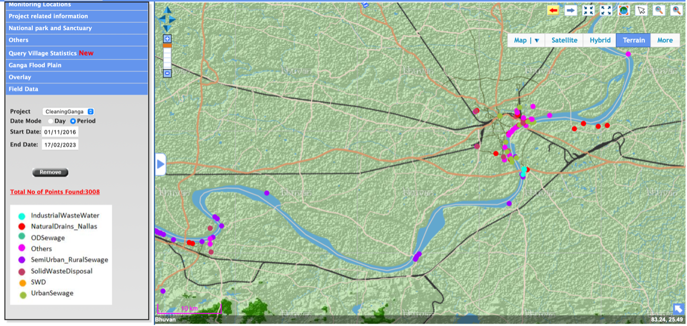
The citizens capture real-time images of polluted areas within and surrounding River Ganga using smartphones. The location information (coordinates) of where the images are taken is also collected using the mobile device Global Positioning System (GPS). The users are also able to add attribute information about pollution sources. The images are then uploaded right away or later on the Bhuvan Ganga Geoportal, which has all geospatial layers related to River Ganga, to check for any river surface pollution (Figure 3). All this information collected is then used by decision makers to prioritise interventions. Therefore, the Bhuvan Ganga Geoportal is used as a tool to support decision making and planning for the Clean Ganga Mission.
Smartphone technology revolutionising citizen science
Despite growing demand for in-situ measurements, the amount of water data being collected in headwater catchments continues to decline in several parts of the world, especially in Africa, Latin America, Asia, and even North America (Davids, 2019). Citizen scientists can systematically help close so called 'water data gaps' by using smart phones.
According to Davids (2019), smartphone technology can be leveraged to gather water data in countries where such data are scarce. GPS technology in smartphones and new advancements such as high-resolution cameras, open up opportunities to make verifiable high-quality scientific observations with photographs and audio recordings. For crowdsourcing, local citizens can use applications on smartphones to capture and upload the data to an online server and database (Figure 4). The metadata generated for each observation can be consistently used to make corrections to raw measurements which is key to ensuring high quality observations (Davids, 2019).

Detectors, sensors or communication systems in waterways can fail because of exposure to moisture, lightning, theft or vandalism. Smartphones therefore become an alternative solution for monitoring water levels, ground water levels and precipitation. Globally, there are various citizen science initiatives (e.g., FreshWaterWatch, CrowdWater, EyeOnWater, SmartPhones4Water, etc.) which use mobile apps for water management – from standing water bodies to streams collecting valuable information about water levels, streamflow quantities, surface water colour, nitrates and phosphates, soil moisture, dynamics of temporary streams, plastic pollution and stream types independently and without the need for any measuring devices.
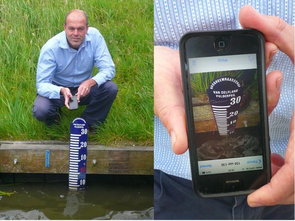
According to Dr. Peter-Jules van Overloop, water monitoring using smartphones can be done by simply taking a picture of a water gauge then uploading it to an app with a server that uses image-processing software to read the water level and stores the location from the joint GPS data (Figure 5) (Wasink, 2014). The Mozambique waterboard get regular readings for its 300 measuring points through crowdsourcing (Wasink, 2014). Monetary incentives were considered as a way of engaging more participants while potentially improving the quality of data collected, for example, the locals would receive one US dollar per measurement in easily accessible measuring points and five US dollars for measurements in remote areas.
Crowdsourcing and Citizen Observatories
Data crowdsourcing is an emerging approach that supports data acquisition from individual citizens, which opens new doors for big data collection and application in water science. Crowdsourced or citizen observations refer to the data collected by a network of citizens using low-cost sensors such as surveillance cameras, car sensors, or smartphones (Davids, 2019). The crowdsourcing framework introduces a strategy to engage citizens in measuring and learning about the conditions of their water bodies such as the quality of their own drinking water. Through effective citizen engagement, crowdsourcing can provide water utilities with cost-effective water quality data in near-real time and rainfall data can be collected at minimal cost and with high temporal and spatial resolution with the assistance of citizens (Niu et al., 2021).
Following a typical crowdsourcing model by Hutchings et al. (2012) (Figure 6), citizens use their mobile phones to report water data and information (e.g., water quality) to a central server. That server receives the information, repackages and shares it via mobile phone messages, websites, dashboards, and social media. When this information gets back to individual citizens/users, they are made aware about the status of their water quality, and water utilities and relevant stakeholders are able to use the data to improve water management.

The next phase in the evolution of citizen science is citizen observatory. Grainger (2017) defines citizen observatory as any use of EO technology in which citizens collect data and are empowered by the information generated from these data to participate in environmental management. Broadly, citizen observatories (COs) are community-based environmental monitoring and information systems, where individuals share their observations, typically using smartphones or through the web.
Citizens and communities participate in water monitoring projects in several ways. Their participation could be mainly by 1) explicitly by providing information via mobile and online portals that were developed in the project, and 2) implicitly by using social media platforms, opportunistically sourced to provide an assessment of evolving situations (Figure 7). For explicit data collection, citizens are encouraged to report if they observe anything of relevance, this is also known as participatory sensing (Mazumdar et al., 2016).
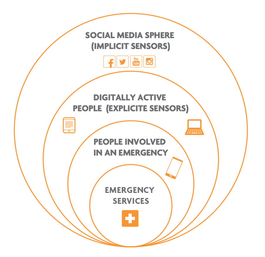
Earth observation is diversifying and now includes new types of systems such as citizen observatories, namely, GroundTruth 2.0, WeSenseIt – Citizen Observatory for Water, GROW Citizens’ Observatory Framework, and more. WeSenseIt: Citizen Observatory of Water was a European Union funded project (2012-2016) that put emphasis on delivering highly innovative technologies to support citizens, local authorities and relevant stakeholders in getting real-time awareness about a situation (e.g., flooding) while respecting the different roles and information needs (Figure 7). On a technical level it combined crowdsourcing and custom applications designed to empower and foster citizen participation with the aims of creating an enriched knowledge base to facilitate the involvement of citizens in decision making for water management (Lanfranchi et al., 2014). Project data capture was based on innovative low-cost sensor devices used by citizens and the exploitation of the citizens’ collective intelligence through crowdsourcing and social media communications analysis (Mazumdar et al., 2016). Wireless sensor networks (WSNs) were used to measure various stages of the water cycle, while citizens can use smartphones to input data on river levels, as measured by gauge boards or by using graduated tapes (Grainger, 2017). The WeSenseIt approach was was successfully tested in three European catchments namely Italy, Netherlands and the United Kingdom, demonstrating and validating:
- the concept of citizens’ observatories - the infrastructure, technology and methodologies developed;
- the usefulness of the direct transfer of environmental conditions and information for policy, industry, research and society; and
- the possibilities for a comprehensive implementation and application of the innovation in varying settings (i.e., differences in topography, climate, land use, social context etc.).
COs have the potential to improve water governance in terms of transparency and accountability as they enable citizens to feed their own observations, experience and expertise into decision making processes. Moreso, in low-income countries where the lack of data is a common problem due to weak monitoring network infrastructures.
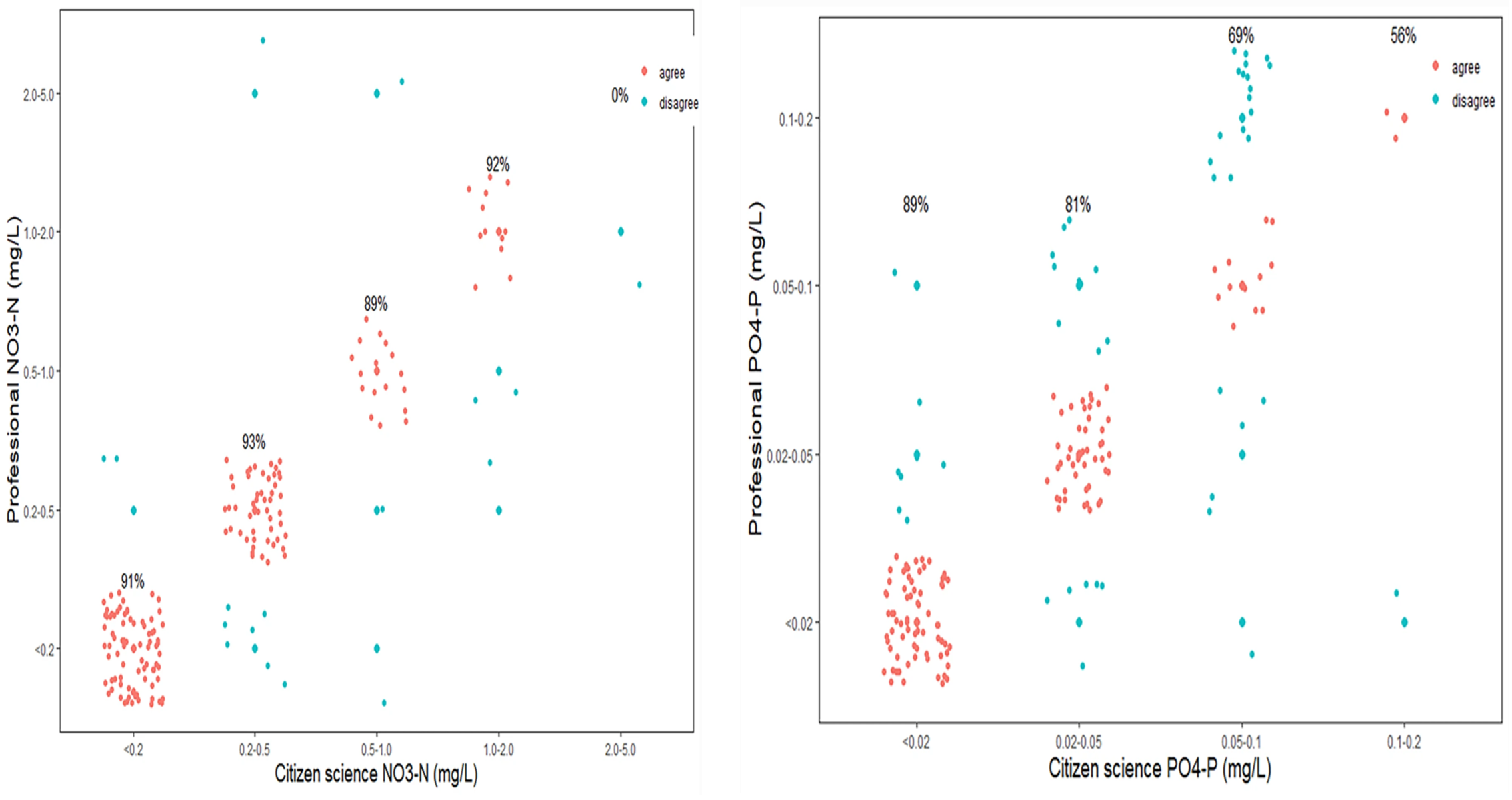
In other cases, citizens work closely with laboratories whereby citizens are trained to collect samples and deliver them to the nearest laboratory for analysis. In Lake Tanganyika for example, citizen scientists were able to monitor nutrient and phosphate levels by collecting water samples from 15 sites in the lake. Samples were taken at each site every month and divided into samples to be measured by both citizen scientists and those to be taken to the laboratory at the Tanzania Fisheries Research Institute (TAFIRI) by professional scientists for validation. Citizens took nitrate and phosphate measurements in closed tubes and performed colorimetric analysis using the Griess method and an enzymatic technique to detect nitrate and phosphate concentrations, respectively (Moshi et al., 2022). Standard calibrated Secchi tubes with detection limits of 14 and 240 Nephelometric Turbidity Units (NTU) were used to take turbidity measurements (Moshi et al., 2022). Citizen scientists recorded these measurements directly onto the FreshWaterWatch app then uploaded to the global database. Collaborations between citizen scientists and professional scientists help eliminate doubts about the accuracy of citizen science collected data as the data is validated in the laboratories (Figure 8).
Assuring quality of crowdsourced and citizen science data
As much as there are several benefits of using crowdsourced and citizen data in terms of filling water data gaps and satellite data validation, there can also be significant uncertainties in the quality of these data. It is important to note that increased volume of data does not necessarily equal to the presence of more useful data. The data collected may be lacking in metadata, may be incomplete, or obtained at a time or place that is not appropriate. Due to this, the need for standards and validation mechanisms arises. Proper quality control is required to filter out crowdsourced observations with overly large errors also known as noisy data. In addition to data quality, ensuring continuity of records is another challenge faced by most citizen science projects. This can mostly be addressed by ensuring a continuous and reliable supply of young citizen scientists who will have longer-term commitments to the projects.
Issues of data quality can be organised into the following categories: accuracy, precision, representativeness, completeness, and comparability. Davids (2019) suggested that accuracy, precision, and completeness issues can be addressed by reviewing the meta data and making any necessary corrections, whereas representativeness and comparability issues can be addressed by providing adequate training for citizens/data collectors and well-designed mobile data collection workflows.
Zheng et al. (2018) provides the following useful summary of eight methods to assure the quality of crowdsourced or citizen science data:
- Comparison with an expert or gold standard data set: comparing crowdsourced data with professionally collected data to assess quality using different quantitative metrics.
- Comparison against an alternative source of data: validating crowdsourced data can against model outputs and using another data set as a proxy for expert data.
- Combining multiple observations: using majority voting or another consensus-based method to combine multiple observations of crowdsourced data.
- Crowdsourced peer review: using citizens’ intelligence to crowdsource information about the quality of other citizen contributions.
- Automated checking: identifying errors in data formatting and consistency and assessing whether the data are within acceptable limits (numerically or spatially).
- Methods from different disciplines: using quality control procedures and standards for assessing spatial data quality.
- Measures of credibility of the information and users: analysing user-based features such as the number of retweets on Twitter or message-based features looking at the level of detail and length of the message.
- Quantification of uncertainty of data and model predictions: identifying potential sources of uncertainty in crowdsourced data and constructing credible measures of uncertainty.
Conclusion
The emergence of new technologies especially smartphone technologies has revolutionised citizen science through enabling citizens and communities to contribute to citizen science in a variety of ways. The potential of citizen science in water management is promising especially with the inclusion of younger populations and participants in developing countries who will harness the power of social networking to a larger effect in all aspects of crowdsourcing - from collecting, validating and open sharing of data as well as multi-stakeholder collaboration. In-situ measurements taken by citizens to support or in absence of water monitoring systems are integral to the calibration and validation of remotely sensed data. In addition, citizen science plays an immense role in bridging water data gaps and ultimately improving integrated water resources management.
Buytaert, W., Zulkafli, Z., Grainger, S., Acosta, L., Alemie, T.C., Bastiaensen, J., De Bièvre, B., Bhusal, J., Clark, J., Dewulf, A., Foggin, M., Hannah, D.M., Hergarten, C., Isaeva, A., Karpouzoglou, T., Pandeya, B., Paudel, D., Sharma, K., Steenhuis, T., Tilahun, S., Van Hecken, G. and Zhumanova, M. “Citizen science in hydrology and water resources: opportunities for knowledge generation, ecosystem service management, and sustainable development”. Frontiers in Earth Science, 2 (26), (2014). https://doi.org/0.3389/feart.2014.00026
Crow, W.T.; Berg, A.A.; Cosh, M.H.; Loew, A.; Mohanty, B.P.; Panciera, R.; De Rosnay, P.; Ryu, D.; Walker, J.P. “Upscaling Sparse Ground-Based Soil Moisture Observations for the Validation of Coarse-Resolution Satellite Soil Moisture Products.” Reviews of Geophysics, 50 (2), (2012): RG2002
Davids, J. C. “Mobilizing Young Researchers, Citizen Scientists, and Mobile Technology to Close Water Data Gaps: Methods Development and Initial Results in the Kathmandu Valley, Nepal”. Published PhD Dissertation, Delft University of Technology, (2019). https://doi.org/10.4233/uuid:9d6f4c39-2439-46cc-bf1a-ba42674bd101
Grainger A. "Citizen Observatories and the New Earth Observation Science." Remote Sensing. 9(2), (2017):153. https://doi.org/10.3390/rs9020153
Gumindoga, W., Rientjes, T. H. M., Haile, A. T., Makurira, H., and Reggiani, P. “Bias correction schemes for 10 CMORPH satellite rainfall estimates in the Zambezi River Basin.” Hydrology and Earth Systems Sciences Discussions. (2016). doi: 10.5194/hess-2016-33
Hut, R. “New Observational Tools and Data Sources for Hydrology”. Published Ph.D. thesis,
Delft University of Technology, (2013). https://doi.org/10.4233/uuid:48d09fb4-4aba-4161-852d-adf0be352227
Hutchings, M., Dev, A., Palaniappan, M., Srinivasan, V., Ramanathan, N., and Taylor, J. “mWASH: Mobile Phone Applications for the Water, Sanitation, and Hygiene Sector.” Pacific Institute, Oakland, California. (2012): 114 p.
Kelly-Quinn, M., Biggs, J.N., Brooks, S., Fortuño, P., Hegarty, S., Regan, F., and Jones, J. I. “Opportunities, approaches and challenges to the engagement of citizens in filling small water body data gaps”. Hydrobiologia (2022). https://doi.org/10.1007/s10750-022-04973-y
Lanfranchi, V., Wrigley, S., Ireson, N., Ciravegna, F. and Wehn, U. “Citizens' Observatories for Situation Awareness in Flooding”. Proceedings of the 11th International ISCRAM Conference – University Park, Pennsylvania, USA, (2014). https://www.researchgate.net/publication/267568722_Citizens'_Observator…
Mao, T., Shangguan, W., Li, Q., Li, L., Zhang, Y., Huang, F., Li, J., Liu, W., Zhang, R. “A Spatial Downscaling Method for Remote Sensing Soil Moisture Based on Random Forest Considering Soil Moisture Memory and Mass Conservation.” Remote Sensing, 14, (2022):3858. https://doi.org/10.3390/rs14163858
Mazumdar, S., Lanfranchi, V., Ireson, N., Wrigley, S., Bagnasco, C., Wehn, U., Mcdonagh, R., Ferri, M., Mccarthy, S. And Huwald, H. “Citizen’s observatories for effective Earth observations: the WeSenseIt approach”. Environmental Scientist, 25 (2), (2016): 56-61.
NASA ARSET. “Connecting Citizen Science with Remote Sensing.” NASA Applied Remote Sensing Training Program (ARSET). Available online: http://appliedsciences.nasa.gov/join-mission/training/english/arset-con… (2023). (Accessed 24 January 2023).
Moshi, H.A., Kimirei, I., Shilla, D., O’Reilly, C., Wehrli, B., Ehrenfels, B. and Loiselle, S. “Citizen scientist monitoring accurately reveals nutrient pollution dynamics in Lake Tanganyika coastal waters.” Environmental Monitoring Assessment, 194 (689), (2022).
National Remote Sensing Centre and ISRO. “A mobile app for public participation in Clean Ganga Mission.” Bhuvan Ganga Mobile App Manual. (2015).Available online: https://bhuvan-app1.nrsc.gov.in/mowr_ganga/usrtasks/ganga/get/BhuvanGan…
Niu, G., Yang, P., Zheng, Y., Cai, X., and Qin, H. "Automatic quality control of crowdsourced rainfall data with multiple noises: A machine learning approach". Water Resources Research, 57, (2021): e2020WR029121. https://doi.org/10.1029/2020WR029121
Pratapwar, G. “Water Pollution in River Ganga.” International Journal of Science and Research (IJSR), 8(2), (2019): 7.426.
The Global Learning and Observations to Benefit the Environment (GLOBE) Program. "About GLOBE." (2023). Available online: https://www.globe.gov/about
United Nations Water (UN Water). Water Scarcity. Water Facts. (2023). Available online: https://www.unwater.org/water-facts/water-scarcity (Accessed 21 February 2023).
Valdés-Pineda, R., Demaría, E. M. C., Valdés, J. B., Wi, S. and Serrat-Capdevila, A. “Bias correction of daily satellite-based rainfall estimates for hydrologic forecasting in the Upper Zambezi, Africa.” Hydrology and Earth System Sciences Discussions, (2016). doi:10.5194/hess-2016-473, 2016
Wasink, Josh. “Water management by crowdsourcing.” Delta - TU Delft Journalistic Platform: Science. Available online: https://www.delta.tudelft.nl/article/watermanagement-crowdsourcing (June 04, 2014). (Accessed 13 January 2023).
Zheng, F., Tao, R., Maier, H. R., See, L., Savic, D., Zhang, T., Chen, Q., Assumpção, T. H., Yang, P., Heidari, B., Rieckermann, J., Minsker, B., Bi, W., Cai, X., Solomatine, D. and Popescu, I. “Crowdsourcing Methods for Data Collection in Geophysics: State of the Art, Issues, and Future Directions”. Reviews of Geophysics 56 (698), (2018).


