Remote sensing in managing, maintaining, and understanding coral reef ecosystems
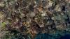
Coral reefs provide integral services to social, economic, and ecological systems. They support more than 500 million livelihoods worldwide and account for 15% of gross domestic product in more than 20 countries. A quarter of all marine species on planet Earth, representing 28 of the 35 animal phyla, can be found in coral reefs, and novel compounds derived from these organisms provide numerous useful medicinal applications.