From Nile floods to satellites: Humanity’s long quest to measure water
For as long as people have lived near rivers and seas, we have watched the water, measured it and tried to understand it because our survival depended on it. In fact, ancient Egyptians built nilometers along the Nile more than 5,000 years ago to predict floods while in China early engineers estimated the speed of rivers with floating objects. In Europe thinkers like Leonardo da Vinci designed new ways to track river flow. These early methods were innovative for their time, but they could only measure flow velocity and water level in one spot. Even today, despite networks of gauges and sensors, most of Earth’s rivers, lakes, and wetlands remain largely unmeasured (Encyclopedia of the Environment, n.d.).
At the same time, our need for water knowledge has never been greater. Climate change is driving stronger floods, longer droughts and rising seas which are threatening communities worldwide. To prepare, we need a way to see the whole picture of Earth’s water systems, not just local fragments.
That is where the Surface Water and Ocean Topography (SWOT) mission comes in. For the first time in history, a single satellite can map almost all the surface water of our planet, helping us better understand floods, droughts or changing coastlines. This global view supports efforts under sustainable Development Goals (SDG) 6 (Clean Water and Sanitation) and 13 (Climate Action). By improving our understanding of ocean circulation, SWOT also contributes to SDG 14 on Life Below Water.
Seeing water in three dimensions: The SWOT mission
The SWOT mission is the first satellite designed specifically to measure the height and movement of surface water globally. This ranges from large rivers and lakes to oceans and coastal zones. Earlier satellites could only measure water along a narrow line while passing overhead, but SWOT scans a 120-kilometre-wide strip, creating maps of rivers, lakes and oceans that reveal how they change over time. The mission covers about 90 per cent of the surface water on Earth and revisits the same locations every 21 days at an altitude of 891 kilometres in a circular orbit from 78° South to 78° North. This means that scientists and water managers can not only see the current state, such as water level or extent, of rivers, lakes and oceans but also track how they change over time. SWOT is the result of a collaboration between the National Aeronautics and Space Administration NASA), Centre National d'Etudes Spatiales (CNES), the Canadian Space Agency (CSA) and the UK Space Agency (UKSA) (CNES, n.d.-b), (NASA, n.d.-b), (AVISO, n.d.-b).
The instruments on board: How a pair of space antennas acts like Earth’s new water gauge
Launched on 16 December 2022, SWOT has six instruments onboard. The main instrument is called the Ka-band Radar Interferometer (KaRIn). It uses two radar antennas mounted 10 metres apart on a boom that extends from the satellite. KaRIn transmits radar pulses at 35.75 Gigahertz (Ka-band) and measures how the signal bounces back from the water. By using two antennas instead of one, it captures a view that can be compared to the way our eyes work. The two antennas look at the same patch of water from slightly different angles. By comparing the two radar signals, the instrument can calculate the height of the water surface across a wide strip. In simple terms, SWOT works like a giant stereo camera in space, turning flat radar data into three-dimensional pictures of rivers and seas.
The swath width that SWOT captures is 120 kilometres, split into two 60-kilometre strips on either side of the path of the satellite and a 20-kilometre gap in the middle. To fill the information in this gap, SWOT carries a nadir radar altimeter, called Poseidon-3C, that points straight down and measures water height directly beneath the satellite. Poseidon-3C continues a long record of ocean measurements that started with earlier satellites in the 1990s (Aviso, n.d.). Additionally, Poseidon-3C measures ocean wave height and surface wind speed which are useful for understanding the state of the sea. The measurement concept is shown in Figure 1.
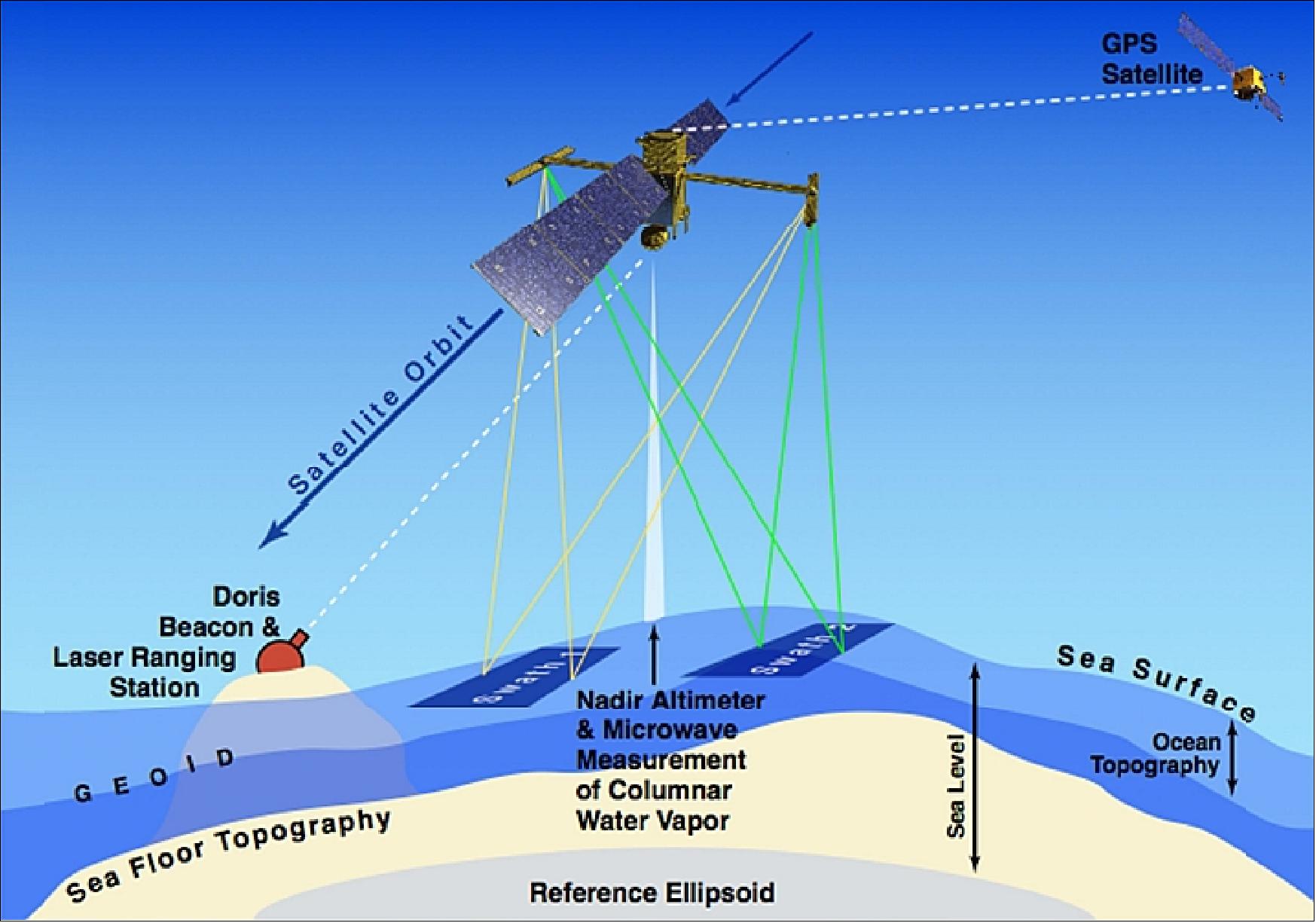
With this principal, SWOT can provide two dimensional maps showing both, the height and the shape of water bodies as illustrated in Figure 2 (NASA, n.d.-b).

Alongside KaRIn, SWOT carries several supporting instruments. One of them is the Advanced Microwave Radiometer (AMR), which measures natural microwave radiation from the atmosphere to estimate how much water vapour is present. This information is used to correct the radar signals, making sure that water heights are measured as precisely as possible.
To know the exact position of the satellite, SWOT carries several navigation systems. The Doppler Orbitography by Radiopositioning Integrated on Satellite (DORIS) receiver uses radio signals from a network of ground stations to fix its orbit. A GPS receiver provides extra positioning data. The satellite also has a laser retroreflector. This is a set of mirrors that reflect laser pulses sent from Earth. These systems ensure that water height measurements are tied to a reliable reference frame (CNES, n.d.-a).
KaRIn: The heart of the mission
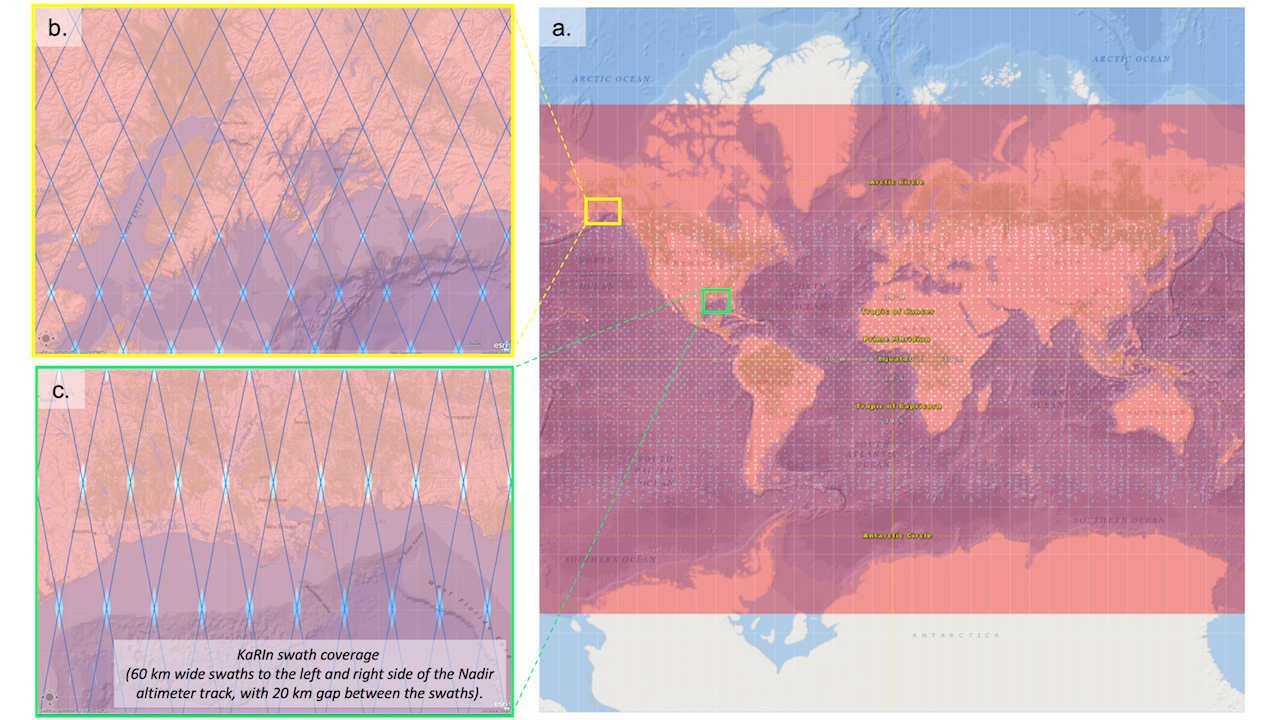
The main instrument of the SWOT mission, KaRIn, operates in two modes. Over the ocean, it collects data at a lower resolution but processes much of it on board the satellite already to reduce the data volume before transmission to Earth. This is called the Low Rate (LR) observation mode. It allows scientists to measure changes in ocean features such as eddies and currents down to about 15 kilometres across. Figure 3 shows the coverage and the geometry of the LR mode at high latitudes (Figure 3b., Yukon Peninsula) and low latitudes (Figure 3c., Mississippi Delta). The map clearly shows how orbital inclination affects the spatial coverage of SWOT, which is the reason why 10 per cent of the globe cannot be observed by the mission.
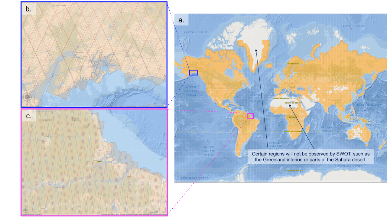
Over land SWOT switches to a high resolution, also referred to as High Rate (HR) mode, designed for hydrology studies of rivers, lakes and reservoirs. This allows to detect rivers wider than 100 metres and lakes larger than 250 by 250 metres. The yellow area in Figure 4 shows where SWOT data at the given resolution is available for terrestrial water features such as rivers, lakes or reservoirs. Panel b. and c. show example areas, namely the Cook Inlet and the Amazon River Delta (NASA, n.d.-b).
Over land the horizontal accuracy of SWOT is about 50 metres with vertical accuracy of about 10 centimetres. Over the ocean, it has horizontal accuracy of about 1 kilometre and vertical accuracy of about one centimetre (NASA, n.d.-b, NASA Earthdata, 2024).
What SWOT aims to discover and why it matters
The introduced instruments support the achievement of the mission’s objectives, with the scientific objective being:
“The Swot mission aims to measure water heights (and their space-time variations) of rivers, lakes and flooded zones as well as the ocean mesoscale and submesoscale circulation. The interferometric altimetry enables to give a bi-dimensional image with a horizontal resolution of about 5 m (along-track) x 10-70 m over land, and 250 m x 250 m over ocean.” (AVISO, n.d.-b)
For the terrestrial hydrosphere, the mission aims to map changes in surface water storage. It becomes possible to estimate river discharge, track changes in lake and reservoir storage and improve flood forecasting systems by combining the satellite data with weather predictions and hydrological models (AVISO, 2025, NASA JPL, 2025).
In coastal zones, SWOT supports the study of estuaries, tides and the marine geoid as well as nearshore bathymetry. These are dynamic environments where land and sea interact and where information is needed for managing risks such as storm surges, saltwater intrusion and erosion (NASA JPL, 2025).
As a global initiative the mission also aims to make its data widely available. Each day ground stations receive data from SWOT’s payload module up to 21 times, ensuring that the measurements from KaRIn and other instruments can be processed and distributed to research and applications communities (NASA Earthdata, 2024).
These objectives make SWOT not just a scientific mission but a practical tool for monitoring the water cycle that sustains life.
Turning data into insight: What SWOT means for water and climate
With SWOT in orbit, the mission is moving from theory to practice. The ability to map surface water globally with high resolution and repeat coverage fills gaps in hydrology and oceanography. In essence, SWOT connects the dots between rivers, lakes and oceans, helping us see how water moves across the entire planet. In the past, most rivers and lakes were monitored only at gauge stations, and many basins had no systematic observations at all. In the traditional radar altimeters for ocean monitoring revealed patterns, such as El Niño, but missed smaller eddies and currents that are crucial for the transport of heat and nutrients (NASA JPL, 2023, AVISO, n.d.-c).
Oceanography
Data from the SWOT mission is used for the measurement of sea-surface height anomalies (SSHA) and to map eddies and filaments. These small sub mesoscale ocean features are essential for understanding transports in the ocean (Archer et al., 2025, Zhang et al., 2024). Other features on this scale include waves and currents with less than 100 kilometres width. A visualisation of SSHA variation is shown in Figure 5.
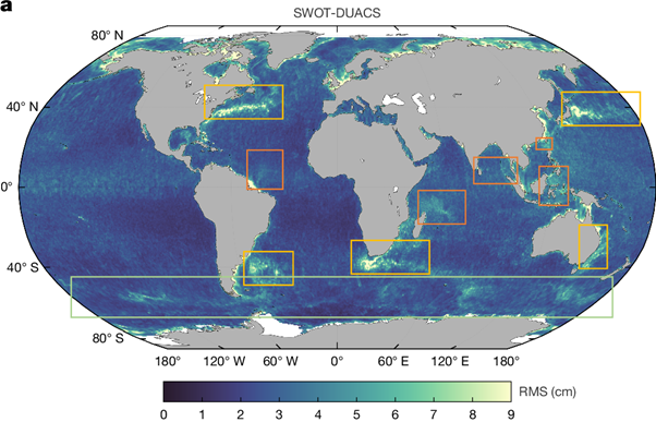
The Root Mean Square (RMS) difference in Figure 5 highlights regions where SWOT observes variability in sea surface height not captured by other altimeters, or in this case the Data Unification and Altimeter Combination System (DUACS). Highlighted are the western boundary currents (yellow boxes), the Antarctic Circumpolar Current (green box) and zones of strong internal tides (orange boxes).
Synthetic Aperture Radar (SAR) and sunglint imagery have already revealed nonlinear internal solitary wave packets. What distinguishes SWOT from these systems is that it can also measure the amplitude of the solitary wave packet. Swell waves, however, are filtered out because of the high signal-to-noise ratio (SNR) of the KaRIn instrument (Archer et al., 2025).
SWOT can even record tsunami waves triggered by earthquakes (AVISO, 2025). On 30 July 2025, an earthquake of magnitude 8.8 off the Kamchatka Peninsula generated a tsunami that SWOT detected 70 minutes later (NASA, 2025). Figure 6 shows how the measurements of the satellite compare with a forecast produced by the U.S. National Oceanic and Atmospheric Administration (NOAA). The leading edge of the tsunami wave reached a height of 45 centimetres above sea level and is shown in red.
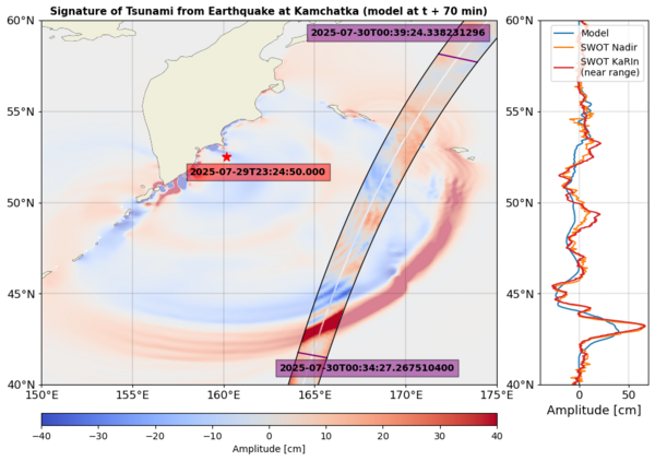
The ability to measure height, shape and direction of tsunamis is helping scientists to improve tsunami forecast models. As SWOT program scientist and Earth lead at NASA Nadya Vinogradova Shiff, stated:
“The power of SWOT’s broad, paintbrush-like strokes over the ocean is in providing crucial real-world validation, unlocking new physics, and marking a leap towards more accurate early warnings and safer futures.” (NASA, 2025)
Even tsunamis caused by landslides have been studied using SWOT. In September 2023, the satellite detected signals of a long-lasting seiche, or standing wave, in Dickson Fjord that continued for nine days (NASA JPL, 2024, AVISO, n.d.-a). Furthermore, in polar regions, SWOT observes sea ice cover, which is important for a better understanding of ocean dynamics (Kacimi et al., 2025).
Terrestrial Hydrosphere
SWOT can monitor surface water bodies (particularly rivers and lakes) under all weather conditions. The generated mission data has been used to estimate river discharge (Durand et al., 2023). A global study even shows that SWOT can extend monitoring of river networks to places with few or no gauges. The global assessment indicates that SWOT can reliably track river discharge variability using satellite data alone, with a median correlation of 0.73 against in-situ measurements, signifying strong agreement in flow timing and variability (Andreadis et al., 2025). The SWOT River Database (SWORD) allows users to browse and visualise predefined river reaches and nodes, providing attributes such as water surface elevation, width and slope (SWOT River Database (SWORD), n.d.). SWORD builds on foundational datasets like the Global River Width from Landsat (GRWL) or the Global River Obstruction Database (GROD) (Yang et al., 2022, Allen & Pavelsky, 2018).
SWOT is also capable of capturing other extreme events. During the Amazon River Basin drought in 2023, it revealed extensive regions of critically low river levels (Moreira et al., 2025). In May 2024, researchers used SWOT to examine severe flooding in southern Brazil, showing how winds and surface slopes intensified flooding across the lagoon system in the state of Rio Grande do Sul, where thousands of people were displaced (Laipelt et al., 2025).
To validate SWOT observations, scientists rely on in-situ data for comparison. The SWOT Adopt-a-Crossover (AdAC) Consortium coordinates field campaigns at so called satellite crossover points. These are locations where paths of the satellite intersect, and the data coverage is high. Through AdAC, research teams in places like the Mid-Atlantic Bight (MAB-SWOT), the Western Mediterranean (BIOSWOT-Med) and the Balearic Sea (FaSt-SWOT) have deployed gliders, drifters and HF radars at the same time as SWOT overpasses (SWOT AdAC Consortium , n.d.)
Why SWOT matters beyond the scientific community
The SWOT mission was designed not only to collect data but also to make that data usable for a wide range of people. To prepare for this, the SWOT Early Adopters Programme (EAP) was launched in 2018. Around 40 institutions worldwide agreed to test SWOT data in real applications (NASA, n.d.-a; Srinivasan et al., 2018). Their work ranges from estimating river discharge in data scarce basins to improving models of ocean circulation (University of Washington, n.d. CNES, n.d.-b). The EAP has organised workshops and training events, including online hackathons. These activities have helped participants build tools, workflows and methods for SWOT data. With support from the SWOT science team the programme has also developed an open library of tutorials, videos and training materials that are freely available to anyone. This was achieved with support from space agencies such as CNES and NASA and from data-hosting services like PO.DAAC and AVISO. The aim was to ensure that researchers, water managers and students worldwide can begin working with SWOT data as soon as it is released (Hossain et al., 2020).
A range of resources that are available for anyone who wants to get started are listed here:
- The SWOT Training page at the University of Washington provides manuals, presentations, and online materials developed by the SWOT Applications Working Group. These include workshops on hydrology and oceanography applications and step-by-step tutorials.
- The SWOT DIY page offers interactive “do-it-yourself” guides and simulator tools. These let users experiment with SWOT-like data before real observations were available.
- NASA’s SWOT Data page explains how to access the datasets through Earth science data portals and provides links to user guides and documentation.
- The SWOT Track Visualizer lets users see where the satellite has been or will be on a given day. By following the satellite’s path, researchers can plan fieldwork and in situ measurements that align with SWOT’s overpasses.
- The Search SWOT’s Pass-over Time tool allows users to select an area of interest and find when the satellite will pass over it. Results are displayed on a map and in tables, making it easier to match SWOT observations with local studies.
- The SWOT Spatial Coverage tool provides downloadable files that show where SWOT data is available. These files can be opened in Google Earth and linked directly to Earthdata search results, helping users quickly locate and access SWOT datasets.
More insights and tutorials can be found here: PO.DAAC cookbook - SWOT data tutorials.
Conclusion: A shared view of water for a changing world
The timing of SWOT is important. As climate change intensifies floods, droughts, and sea-level rise, governments and communities need reliable water information to prepare and adapt. By combining global coverage with open access to data, SWOT offers a tool not just for science but also for cooperation. The mission demonstrates how international partnerships in space can support shared water management, strengthen disaster preparedness and improve understanding of the Earth system at a moment when this knowledge is urgently needed.

Allen, G. H., & Pavelsky, T. M. (2018). Global extent of rivers and streams. Science, 361(6402), 585–588. https://doi.org/10.1126/SCIENCE.AAT0636/SUPPL_FILE/AAT0636_ALLEN_SM_DATA_S1.ZIP
Andreadis, K. M., Coss, S. P., Durand, M., Gleason, C. J., Simmons, T. T., Tebaldi, N., Bjerklie, D. M., Brinkerhoff, C., Dudley, R. W., Gejadze, I., Larnier, K., Malaterre, P. O., Oubanas, H., Allen, G. H., Bates, P. D., David, C. H., Domeneghetti, A., Elmi, O., Marc, L. F., … Yadav, B. (2025). A First Look at River Discharge Estimation From SWOT Satellite Observations. Geophysical Research Letters, 52(9), e2024GL114185. https://doi.org/10.1029/2024GL114185.
Archer, M., Wang, J., Klein, P., Dibarboure, G., & Fu, L. L. (2025). Wide-swath satellite altimetry unveils global submesoscale ocean dynamics. Nature, 640(8059), 691–696. https://doi.org/10.1038/S41586-025-08722-8.
AVISO. (n.d.-a). Earthshaking waves from a landslide observed by Swot in a fjord. Retrieved September 3, 2025, from https://www.aviso.altimetry.fr/en/missions/current-missions/swot/portfolio-of-swot-first-results/earthshaking-waves-from-a-landslide-observed-by-swot-in-a-fjord.html
Aviso. (n.d.). Poseidon-3C. Retrieved November 5, 2025, from https://www.aviso.altimetry.fr/en/missions/current-missions/swot/instruments/poseidon-3c.html
AVISO. (n.d.-b). SWOT. Retrieved September 1, 2025, from https://www.aviso.altimetry.fr/en/missions/current-missions/swot.html
AVISO. (n.d.-c). Swot monitors its first El Niño. Retrieved September 3, 2025, from https://www.aviso.altimetry.fr/en/missions/current-missions/swot/portfolio-of-swot-first-results/swot-monitors-its-first-el-nino.html
AVISO. (2025). A third tsunami observed by SWOT, due to Kamchatka earthquake. https://www.aviso.altimetry.fr/en/missions/current-missions/swot/portfolio-of-swot-first-results/a-third-tsunami-observed-by-swot-due-to-kamchatka-earthquake.html
CNES. (n.d.-a). DORIS . Retrieved August 26, 2025, from https://cnes.fr/projets/doris
CNES. (n.d.-b). SWOT |. Retrieved September 1, 2025, from https://cnes.fr/projets/swot
Durand, M., Gleason, C. J., Pavelsky, T. M., Prata de Moraes Frasson, R., Turmon, M., David, C. H., Altenau, E. H., Tebaldi, N., Larnier, K., Monnier, J., Malaterre, P. O., Oubanas, H., Allen, G. H., Astifan, B., Brinkerhoff, C., Bates, P. D., Bjerklie, D., Coss, S., Dudley, R., … Wang, J. (2023). A Framework for Estimating Global River Discharge From the Surface Water and Ocean Topography Satellite Mission. Water Resources Research, 59(4), e2021WR031614. https://doi.org/10.1029/2021WR031614.
Encyclopedia of the Environment. (n.d.). A brief history of hydrometry. Unesco. Retrieved August 27, 2025, from https://www.encyclopedie-environnement.org/en/zoom/a-brief-history-of-hydrometry/
eoPortal. (n.d.). SWOT (Surface Water Ocean Topography) . Retrieved September 1, 2025, from https://www.eoportal.org/satellite-missions/swot#measurement-concept
Hossain, F., Bonnema, M., Srinivasan, M., Beighley, E., Andral, A., Doorn, B., Jayaluxmi, I., Jayasinghe, S., Kaheil, Y., Fatima, B., Elmer, N., Fenoglio, L., Bales, J., Lefevre, F., Legrand, S., Brunel, D., & Le Traon, P. Y. (2020). The early adopter program for the surface water ocean topography satellite mission: Lessons learned in building user engagement during the prelaunch era. Bulletin of the American Meteorological Society, 101(3), E259–E264. https://doi.org/10.1175/BAMS-D-19-0235.1
Kacimi, S., Jaruwatanadilok, S., & Kwok, R. (2025). SWOT Observations Over Sea Ice: A First Look. Geophysical Research Letters, 52(10), e2025GL116079. https://doi.org/10.1029/2025GL116079.
Laipelt, L., de Paiva, R. C. D., Fan, F. M., Collischonn, W., Papa, F., & Ruhoff, A. (2025). SWOT Reveals How the 2024 Disastrous Flood in South Brazil Was Intensified by Increased Water Slope and Wind Forcing. Geophysical Research Letters, 52(2), e2024GL111287. https://doi.org/10.1029/2024GL111287.
Moreira, D., Papa, F., Fassoni-Andrade, A., Fleischmann, A., Wongchuig, S., Paiva, R., Paris, A., Frappart, F., Melo, J., Crétaux, J. F., Santos, A. M., Garambois, P. A., Kitambo, B., & Calmant, S. (2025). Widespread and Exceptional Reduction in River Water Levels Across the Amazon Basin During the 2023 Extreme Drought Revealed by Satellite Altimetry and SWOT. Geophysical Research Letters, 52(11), e2025GL116180. https://doi.org/10.1029/2025GL116180.
NASA. (n.d.-a). Early Adopters. Retrieved September 1, 2025, from https://swot.jpl.nasa.gov/applications/early-adopters/
NASA. (n.d.-b). Surface Water and Ocean Topography (SWOT). Retrieved September 1, 2025, from https://podaac.jpl.nasa.gov/SWOT?tab=mission-objectives§ions=about%2Bnews
NASA. (2025, August 7). US-French SWOT Satellite Measures Tsunami After Massive Quake. https://www.nasa.gov/missions/swot/us-french-swot-satellite-measures-tsunami-after-massive-quake/
NASA Earthdata. (2024, October 22). NASA’s Surface Water and Ocean Topography (SWOT) Mission Data Release. https://www.earthdata.nasa.gov/news/feature-articles/nasas-surface-water-ocean-topography-swot-mission-data-release
NASA Jet Propulsion Laboratory. (n.d.). SWOT Surface Water and Ocean Topography. Retrieved August 20, 2025, from https://swot.jpl.nasa.gov/
NASA Jet Propulsion Laboratory (JPL). (2023, November 8). SWOT Monitors El Niño off Peru. https://www.jpl.nasa.gov/images/pia26181-swot-monitors-el-nino-off-peru/
NASA JPL. (2024, October 31). International SWOT Satellite Spots Planet-Rumbling Greenland Tsunami – NASA SWOT. https://swot.jpl.nasa.gov/news/165/international-swot-satellite-spots-planet-rumbling-greenland-tsunami/
Srinivasan, M., Peterson, C., & Andral, A. (2018). SWOT Early Adopters Guide. https://swot.jpl.nasa.gov/science/
SWOT AdAC Consortium. (n.d.). Retrieved September 2, 2025, from https://www.swot-adac.org/
SWOT River Database (SWORD). (n.d.). Retrieved September 3, 2025, from https://www.swordexplorer.com/
University of Washington. (n.d.). SWOT Applications. Sustainability, Satellites, Water, and Environment (SASWE) Research Group. Retrieved September 2, 2025, from http://depts.washington.edu/saswe/swot/ea-publications.html
Yang, X., Pavelsky, T. M., Ross, M. R. V., Januchowski-Hartley, S. R., Dolan, W., Altenau, E. H., Belanger, M., Byron, D., Durand, M., Van Dusen, I., Galit, H., Jorissen, M., Langhorst, T., Lawton, E., Lynch, R., Mcquillan, K. A., Pawar, S., & Whittemore, A. (2022). Mapping Flow-Obstructing Structures on Global Rivers. Water Resources Research, 58(1), e2021WR030386. https://doi.org/10.1029/2021WR030386
Zhang, Z., Miao, M., Qiu, B., Tian, J., Jing, Z., Chen, G., Chen, Z., & Zhao, W. (2024). Submesoscale Eddies Detected by SWOT and Moored Observations in the Northwestern Pacific. Geophysical Research Letters, 51(15), e2024GL110000. https://doi.org/10.1029/2024GL110000.