India

Alpha 3
IND

Related Content

Article

Pénuries d'Eau en Milieu Urbain : Comment les Données de la Mission GRACE-FO de la NASA Peuvent-Elles Soutenir la Gestion de l'Eau en Temps Quasi-Réel ?

Plus la population augmente, plus la demande en eau augmente, notamment l'eau nécessaire aux usages domestiques, industriels et municipaux (Mogelgaard 2011). L'Inde en est un bon exemple : le 20 juin 2019, la ville de Chennai a failli manquer d'eau. Des images satellites ont montré l'ampleur de la pénurie d'eau dans la ville (schéma 1). Alors que les habitants faisaient la queue pour de l'eau stockée dans des camions-citernes qui la rendaient disponible dans la ville, le véritable défi de gestion concernait les bâtiments municipaux et les entreprises de la ville. La pénurie d´eau a gravement affecté la capacité des hôpitaux à soigner les patients et à nettoyer les équipements, et a contraint les entreprises à fermer leurs portes jusqu'à la fin de la crise.

Hydro-diplomacy: The role of space-derived data in advancing water security

Water scarcity is one of the greatest threats faced by humanity of our time – in 2019, more than two billion people experience high water stress (UN-Water 2019) and approximately four billion people suffer from severe water scarcity for at least one month per year (Mekonnen and Hoekstra 2016). This worsening problem increases the risk of international conflict over water resources breaking out, given that there are over 270 transboundary river basins, and three-quarters of UN Member States share at least one river or lake basin with a neighbour (UN News 2017).

Relation of extreme precipitation with temperature: How do open-access global gridded datasets work in a hydrometeorological study?

Analysts have long noted that extreme precipitation appears to intensify with temperature at a rate of around 7%/°C, which is governed by the Clausius-Clapeyron (CC) equation. This study aims to investigate the relationship between the spatio-temporal properties of hourly precipitation and daily dew point temperature. Specifically, the global gridded products of bias-corrected Climate Prediction Center morphing technique (CMORPH-CRT) and ERA5 reanalysis were applied for nine locations in the world. The results show that significant spatial heterogeneity in extreme precipitation scaling is present at the selected locations, which might be attributed to local conditions, such as regional climate and the proximity to humidity sources. Despite the potential limitations, this study provides insight into the application of high-resolution open-access global gridded products in analysing precipitation scaling.

Urban Water Scarcity: How data from NASA’s GRACE-FO Mission can be used for (near) real time water management

As population becomes larger the demand for water soars, including water needed for domestic, industrial and municipal uses (Mogelgaard 2011). One example of that, is India, where on 20 June 2019 the city of Chennai almost run out of water. Satellite images show the extent of the water shortage in the city (figure 1). While people are queuing up to get water from water trucks that transfer water to the city, the greatest struggle is taking place in the city’s municipal buildings and businesses. Hospitals are facing the threat of not having enough water to treat patients and to clean equipment, and businesses are forced to shut down and wait until the crisis is over.

Escasez urbana de agua: cómo pueden utilizarse los datos de la misión GRACE-FO de la NASA para la gestión del agua (casi) en tiempo real

As population becomes larger the demand for water soars, including water needed for domestic, industrial and municipal uses (Mogelgaard 2011). One example of that, is India, where on 20 June 2019 the city of Chennai almost run out of water. Satellite images show the extent of the water shortage in the city (figure 1). While people are queuing up to get water from water trucks that transfer water to the city, the greatest struggle is taking place in the city’s municipal buildings and businesses. Hospitals are facing the threat of not having enough water to treat patients and to clean equipment, and businesses are forced to shut down and wait until the crisis is over.

Interview with Farid Farhat, Hydrological Modeling Specialist at UNICITI

Could you describe how your professional and/or personal experience relate to water? Where does your interest in space technology for water come from? 

I have a solid understanding of the fundamentals of hydrologic and hydraulic engineering, which is relevant to water. I studied many courses in my undergraduate and postgraduate degrees where I learned how runoff in a watershed is generated from meteorological parameters including rainfall, evapotranspiration and infiltration. I also applied my theoretical knowledge to various projects.

Local Perspectives Case Studies

Map

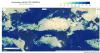
Click on any of the highlighted countries to retrieve further information.

Stakeholder

National Space Science Agency

NSSA seeks to establish a sound infrastructure for the observation of outer space and the earth, make Bahrain a leader in space science and technology, build a culture and methodology of scientific research within the kingdom and encourage technical innovation, among other goals. NSSA is interested in satellites to obtain data, to use them for remote sensing and to conduct advanced space research, so it can be the engine for the state in the use of the latest satellite communication technologies.

NSSA’s main projects are as follows:

Global Water Partnership

The Global Water Partnership (GWP) is a global action network with over 3,000 Partner organisations in 179 countries. The network has 69 accredited Country Water Partnerships and 13 Regional Water Partnerships.

The network is open to all organisations involved in water resources management: developed and developing country government institutions, agencies of the United Nations, bi- and multi-lateral development banks, professional associations, research institutions, non-governmental organisations, and the private sector.

International Water Management Institute

IWMI is a research-for-development (R4D) organization, with offices in 13 countries and a global network of scientists operating in more than 30 countries. For over three decades, our research results have led to changes in water management that have contributed to social and economic development. IWMI’s Vision reflected in its Strategy 2019-2023, is ‘a water-secure world’.

University of Stirling

The University of Stirling (www.stir.ac.uk) was founded by Royal Charter in 1967 as the first genuinely new university in Scotland for over 400 years and embraces its role as an innovative, intellectual and cultural institution. A research-led university with an international reputation for high-quality research directly relevant to society’s needs, Stirling aims to be at the forefront of research and learning that helps to improve lives.

International Institute for Applied Systems Analysis

The International Institute for Applied Systems Analysis (IIASA) is an independent, international research institute with National Member Organizations in Africa, the Americas, Asia, and Europe. Through its research programs and initiatives, the institute conducts policy-oriented research into issues that are too large or complex to be solved by a single country or academic discipline. This includes pressing concerns that affect the future of all of humanity, such as climate change, energy security, population aging, and sustainable development.

Govind Ballabh Pant University of Agriculture and Technology Pantnagar

G. B. Pant University of Agriculture and Technology, also known as Pantnagar University, is the first agricultural university in India. The University lies in the campus town of Pantnagar in Kichha Tehseel and in the district of Udham Singh Nagar, Uttarakhand. The university is regarded as the harbinger of the Green Revolution in India. Pantnagar University is regarded as a significant force in the development and transfer of High Yielding Variety of seeds and related technology.

National Mission for Clean Ganga, Ministry of Jal Shakti

National Mission for Clean Ganga (NMCG) is a comprehensive one with high priority for research and evidence-based decision making and has a special place for use of new technology including Geospatial technology. NMCG Authority order of Oct’ 2016 states that the pollution in River Ganga and its tributaries shall be monitored by the use of satellite imagery and other remote sensing technologies.

Tribhuvan University, Institute of Forestry, Pokhara

The Institute of Forestry, Pokhara Campus (IOF-PC), Quality Assurance Accreditation (QAA) certified institution by the UGC, Nepal in September 2022, was established in 1981 as the Central Campus of the Institute of Forestry, one of the five technical institutes under Tribhuvan University, Nepal. The IOF, founded as Nepal Forestry Institute in Singh Durbar, Kathmandu, in 1947, was shifted to Suping (BhimPhedi) in 1957 and again to Hetauda in 1965.

GEO - Global Water Sustainability

Established in 2017 by the Group on Earth Observations - Water Community, GEOGloWS is a voluntary mechanism created by informal agreement among multiple partners from inside and outside the UN system. This mechanism allows for engagement and greater integration with trans-national organizations and agencies with water responsibilities at the National and Local levels.  

Person

Nidhi Bhagatella

Senior Fellow and Cluster Coordinator: Nature, Climate, and Health The United Nations University Institute on Comparative Regional Integration Studies (UNU-CRIS)

Nidhi Nagabhatla is a Senior Fellow and Cluster Coordinator: Nature, Climate, and  Health at United Nations University – CRIS Belgium. As a sustainability science specialist and a systems analyst with nearly 23 years of work experience, she has led, coordinated, and implemented transdisciplinary projects in various geographical regions of Asia, Africa, Europe, and the Americas working with international organizations and leading research and capacity development initiatives.

Photo

Anam Bayazid

Intern United Nations Office for Outer Space Affairs

Anam Bayazid is an engineer with a passion for earth observation and space exploration technologies. Her academic journey involves pursuing a Master of Engineering in Systems Engineering with a concentration in Space Systems at Stevens Institute of Technology in United States. Her specialization is in systems modeling and simulation, as well as designing missions and systems for space exploration.

Nidhi Nagabhatla

Senior Research Fellow The United Nations University Institute on Comparative Regional Integration Studies (UNU-CRIS)

Nidhi Nagabhatla is a Senior Fellow and Cluster Coordinator: Nature, Climate, and  Health at United Nations University – CRIS Belgium. As a sustainability science specialist and a systems analyst with nearly 23 years of work experience, she has led, coordinated, and implemented transdisciplinary projects in various geographical regions of Asia, Africa, Europe, and the Americas working with international organizations and leading research and capacity

Software/Tool/(Web-)App

Bhuvan Ganga App

Bhuvan Ganga App is ISRO’s mobile application developed to enable public to collect and report information on various pollution sources that affects the water quality of river Ganga. This mobile app will provide a platform for crowd sourcing to monitor pollution in river Ganga and enable decision makers at National Mission for Cleaning Ganga (NMCG) under Ministry of Water Resources, River Development & Ganga Rejuvenation, Government of India to prioritize interventions.

Bhuvan Ganga Geoportal

Bhuvan Ganga Geoportal provides platforms to manage, access, visualize, share and analyze geo spatial data, non-spatial data products and services towards spatial mashups to support NMCG objectives of environmental and ecological improvement within the Ganga River basin.