

Дистанционное зондирование в управлении, поддержании и понимании экосистем коралловых рифов
Translated by Marina Agarkova
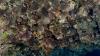
"Habitat mapping involves the mapping and monitoring wildlife habitats to estimate population size, identify critical habitat, and predict the impacts of environmental change. Remote sensing has often been identified as a key data source for supporting habitat mapping" (McDermid, Franklin, and LeDrew 2005)
McDermid, Gregory J., Steven E. Franklin, and Ellsworth F. LeDrew. "Remote sensing for large-area habitat mapping." Progress in Physical Geography 29, no. 4 (2005): 449-474.
