Oil spill monitoring

Related Content

Article

Using space-based technologies to monitor marine oil pollution

Oil spills are a critical form of environmental pollution that have far-reaching negative impacts. They severely degrade marine ecosystems, introducing toxic chemicals into the oceans and harming sea life. They also have significant financial impacts through the diminishment of ecotourism as well as the killing of commercially viable species. Despite these negative impacts, oil spills are notoriously difficult to track and monitor given the general lack of surveillance over the vastness of the Earth’s oceans. Space-based technologies are evolving as a tool to aid in the detection of oil spills worldwide. Two primary technologies have been optimized for oil spill monitoring: optical satellite imagery and synthetic aperture radar (SAR). Optical satellite imagery functions somewhat like taking a photograph of the Earth’s surface and requires clear skies and daylight to produce imagery. SAR imagery, on the other hand, relies on microwaves to produce images, and therefore can function regardless of weather, as well as at night. The combination of these two technologies has allowed scientists an increased ability to monitor where and when oil pollution is happening, providing an eye-in-the-sky to survey marine activities. While these space-based technologies are aiding in the detection of a variety of oil spill incidents, they are particularly helpful to monitor the illegal dumping of oil and effluent from shipping vessels as ships are no longer able to dump oily bilgewater into the ocean under the veil of darkness. Unfortunately, the enforcement of environmental and marine law remains an issue and ships are rarely prosecuted. It will be important for space-based technologies to continue to evolve and provide evidence of marine pollution in the effort to provide protection for Earth’s marine ecosystems.

Utilizando tecnologías espaciales para monitorear la contaminación marina por petróleo

Oil spills are a critical form of environmental pollution that have far-reaching negative impacts. They severely degrade marine ecosystems, introducing toxic chemicals into the oceans and harming sea life. They also have significant financial impacts through the diminishment of ecotourism as well as the killing of commercially viable species. Despite these negative impacts, oil spills are notoriously difficult to track and monitor given the general lack of surveillance over the vastness of the Earth’s oceans. Space-based technologies are evolving as a tool to aid in the detection of oil spills worldwide. Two primary technologies have been optimized for oil spill monitoring: optical satellite imagery and synthetic aperture radar (SAR). Optical satellite imagery functions somewhat like taking a photograph of the Earth’s surface and requires clear skies and daylight to produce imagery. SAR imagery, on the other hand, relies on microwaves to produce images, and therefore can function regardless of weather, as well as at night. The combination of these two technologies has allowed scientists an increased ability to monitor where and when oil pollution is happening, providing an eye-in-the-sky to survey marine activities. While these space-based technologies are aiding in the detection of a variety of oil spill incidents, they are particularly helpful to monitor the illegal dumping of oil and effluent from shipping vessels as ships are no longer able to dump oily bilgewater into the ocean under the veil of darkness. Unfortunately, the enforcement of environmental and marine law remains an issue and ships are rarely prosecuted. It will be important for space-based technologies to continue to evolve and provide evidence of marine pollution in the effort to provide protection for Earth’s marine ecosystems.

Использование космических технологий для мониторинга загрязнения нефтью морской среды

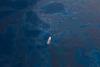
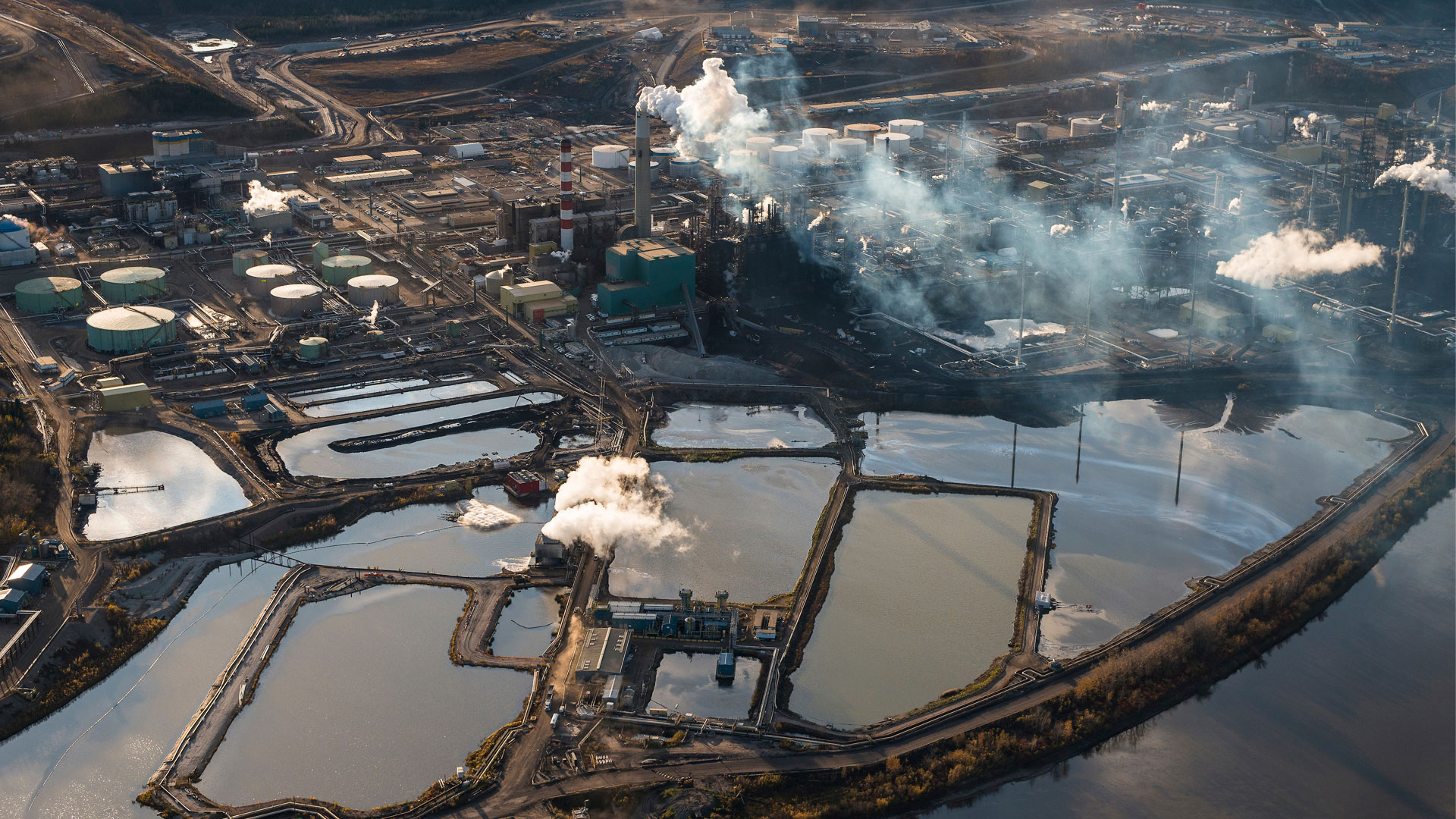
Разливы нефти являются критической формой загрязнения окружающей среды и имеют масштабные негативные последствия. Они серьезно деградируют морские экосистемы, растворяя в океанах токсичные химические вещества и нанося вред морской флоре и фауне. Разливы нефти имеют отрицательно воздействие на финансовое состояние экологического туризма, а также на коммерчески жизнеспособные виды. Кроме этих негативных последствий, разливы нефти трудно отслеживать и контролировать, учитывая в целом отсутствие наблюдения за мировым океаном. Космические технологии действуют как инструмент, помогающий обнаруживать разливы нефти повсеместно. Для мониторинга разливов нефти доступны две основные технологии: оптическая визуализация и радиолокатор с синтезированной апертурой (SAR). Оптическая визуализация работает примерно так же, как фотосъёмка поверхности Земли, и для получения изображений требуется чистое небо и дневной свет. С другой стороны, изображения SAR основаны на микроволнах для их получения, и это делает возможным производить съемку в любую погоду и в любое время суток. Сочетание этих двух технологий позволило ученым расширить возможности мониторинга загрязнения нефтью, обеспечивая контроль за деятельностью на море. Эти космические технологии помогают в обнаружении различных инцидентов разлива нефти, они особенно эффективны для мониторинга незаконного сброса нефти и сточных вод с судов, так как суда больше не могут незаметно сбрасывать нефтесодержащие трюмные воды в океан в ночное время. К сожалению, обеспечение соблюдения экологического и морского права остается трудновыполнимой задачей, и судовладельцы редко привлекаются к ответственности. Важно, чтобы космические технологии продолжали развиваться и помогали предоставлять доказательства загрязнения морской среды для обеспечения защиты морских экосистем Земли.

Local Perspectives Case Studies

Need for water quality data to monitor effects of mining and industrial use of water near Lake Athabasca, Canada

Tar Sands - Photo by Garth Lenz
The community is nestled on the northwest shore of Lake Athabasca and downstream of tar sands/mining extraction and hydroelectric dams. The challenge the community faces is the lack of data on the industry water use and how that is or will affect the community in the future. There is a need for data that will help with informed decision making for active stewardship and monitoring. We have estimated that it will cost about 17 billion dollars in liability if reclamation and remediation is not done to bring back the boreal ecosystem. Therefore, we need data to aid in decision-making and adaptive management to determine whether the current management practices and solutions are effectively working. This could be data on biodiversity, for example of benthic vertebrates to access the health of the water ecosystems and also water quality. Currently we do not have such data. Right now, they are doing progressive reclamation where they are revegetating as they are mining but we cannot evaluate whether this is successful or not. We do not know if the species they are using for revegetation are improving environmental quality or not. We need to develop criteria to determine the success of reclamation by evaluating if specified targets are met with a particular time period and if these are not met then identify what could be done differently – adaptative management.

Project / Mission / Initiative / Community Portal

Oil Spill Detection System in the Arabian Gulf Region: An Azure Machine-Learning Approach

Locating oil spills is a crucial portion of an effective marine contamination administration. In this project, we address the issue of oil spillage location exposure within the Arabian Gulf region, by leveraging a Machine-Learning (ML) workflow on a cloud-based computing platform: Microsoft Azure Machine-Learning Service (Custom Vision). Our workflow comprises a virtual machine, a database, and four modules (an Information Collection Module, a Discovery Show, an Application Module, and a Choice Module).

Space-based Solution