

Overview:
With the latest call by UN Secretary General for a “revolution” in the use of data for sustainable development, geospatial technologies have tremendous potential to boost the movement towards achieving Sustainable Development Goals (SDGs) and to improve monitoring of relevant SDGs’ targets and indicators.
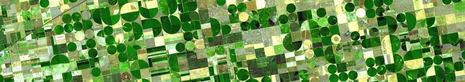
Geospatial technologies and remote sensing offer a crucial location element to the monitoring of SDGs . The unprecedented “power of where” allows for unbiased observation and analysis across borders, administrative boundaries, and nations.
Yet there is still a gap between the technology world and the world of environmental decision- and policy-makers. Despite the tremendous potential digital technologies offer, there are still traditional fears among practitioners that prevent their uptake. Furthermore, these technologies are constantly changing and improving, making it even more difficult for practitioners to track the updates about the potential use and application of technologies, such as geographic information systems (GIS) and remote sensing.
This course is part of a series of ISEPEI’s “Bridging ICTs and the Environment” workshops that aim to address that gap through providing in-service education and professional training. This annual workshop series provides an opportunity for non-specialists to get updated on the latest advances in relevant technologies and to learn how these tools can be applied in SDG monitoring.
This year’s course is organized in cooperation with United Nations Population Fund (UNFPA), so the primary focus in presentations and case studies will be given to demography, as well as health and poverty issues. A large number of the SDG indicators are linked to population and demographic data, or could be derived from census data.
The workshop will cover a number of technologies including remote sensing, geospatial technologies, data collection, and decision-support systems, among others. In particular, the role of satellite-based earth monitoring and remote sensing in achieving SDGs will be discussed, highlighting their potential and limitations.
Theoretical presentations and best use practices in geospatial technologies will be accompanied by practical sessions on their application (e.g. satellite imagery analysis, use of mobile technologies, mapping).
The course consists of 2 online components: preparatory asynchronous stage with prerecorded practical sessions familiarizing participants with basics of geospatial technologies (in June); and week-long synchronous stage (July 5-9th, 3 hours daily, 9-12 am CET) with live online presentations by renowned experts and practitioners accompanied by group discussions and practical exercises. To pass the course participants are expected to attend all online sessions and complete a series of individual assignments.
The course is open for both non-technical practitioners and academia. Previous knowledge of GIS and remote sensing is not required.
Key dates:
- Application - First application deadline: March 22, 2021. Further deadlines and late application policy will be posted on the course websites.
- Early-bird deadline of tuition payment - April 30, 2021
- Full tuition fee payment deadline - May 28, 2021
Target group:
The target group for this course includes academia, both students and faculty, junior professionals from national governmental or affiliated agencies and international organizations, academia and relevant NGO representatives. Within academia the priority will be given to graduate students in public policy and environmental management from OSUN and CIVICA partner institutions. The mixture of professional and student groups should facilitate students / youth / future leaders' engagement at the high-level professional event and stimulate interest in the topic.
We also invite applications from advanced undergraduate students who have adequate prior study or experience on the subject and make a compelling case in their application/statement of interest.
Pre-requisites:
Proven professional and/or academic focus on demography related topic (census, poverty, inequality, etc) or geospatial technologies;
Intermediate computer user skills;
Language requirement:
The language of instruction is English, thus all applicants have to demonstrate a strong command of spoken and written English to be able to participate actively in discussions at seminars and workshops. Some of the shortlisted applicants may be contacted for a telephone interview.
Costs:
Institutions - 250 EUR
Individuals - 150 EUR
Students/CEU Alumni - 100 EUR