Water in the atmosphere, in the soil, in rivers and oceans is in continuous exchange via the global water cycle. This is commonly thought to be the circular movement of water that evaporates from the Earth's surface, rises on warm updrafts into the atmosphere, and condenses into clouds. It is transported by the wind as water vapour, and eventually falls back to the Earth’s surface as rain or snow. Although this general paradigm is not incorrect, the global water cycle is far more complex and involves biophysical processes transferring energy and latent heat between atmosphere, land surface, and vegetation. Monitoring, understanding and predicting water dynamics remains a major challenge for contemporary science and technology (Hegerl et al. 2015) yet is essential for sustainable development (Bhaduri et al. 2016) and managing climate risks. Given the global, regional and subregional nature of hydrological dynamics it is almost unthinkable to monitor them exclusively with ground-based instruments due to their sparse distribution over remote regions. Satellite-based sensors are therefore the only practical solution to acquire the data necessary for water resource management at adequate spatial-temporal resolution (Sheffield et al. 2018).
Managing shared water resources under changing climate inevitably involves also the estimation, mapping and prediction of water risks. These challenging tasks can be aided by the use of mathematical models that ingest space-borne data and ground measurements to turn them into actionable information. The purposes for the use of such information are manifold, and the main users are governmental and non-governmental organizations aiming at the conservation of shared water resources, as well as major water users and private sector actors such as corporations. Achieving sustainable water management by major water users is among the high priority targets for the decade 2020-2030 (UNESCO 2019a; World Economic Forum 2021). This article focuses on the applicative use of global water data to support corporations in managing shared water resources and related risks, and it presents data tools enabling informed decision-making at corporate level.
The water cycle from space
The research and monitoring of the water cycle, at both global and regional scales, include physical processes such as evaporation and condensation, infiltration and surface run-off, which in turn involve multiple hydrological and meteorological variables. Here it is provided a brief description of the main variables of the water cycle monitored from satellite-based sensors, and an overview of the space missions enabling their monitoring.
Water Vapour
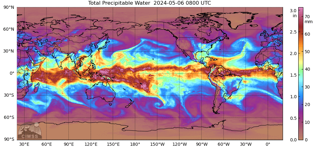
Water vapour represents approximately 0.04% of the water on Earth and its concentration in the atmosphere ranges between 0 and 4% (Gleick 1996). Despite this, water vapour is responsible for most of the horizontal transport of freshwater on the planet. Alike liquid water running on the Earth’s surface, water vapour flows in atmospheric rivers moving from the inter-tropical region outwards (Zhu and Newell 1994).

The Moderate Resolution Imaging Spectre-radiometer (MODIS) aboard the Terra and Aqua satellites, operated by the National Aeronautics and Space Administration (NASA), has been providing continuous, consistent measurements of water vapour, as well as other water-related variables, since the year 2000. As MODIS approaches retirement, its extraordinary long time series of data will be continued and complemented by latest sensors such as Visible Infrared Imaging Radiometer Suite (VIIRS), aboard the joint NASA/NOAA Suomi National Polar-orbiting Partnership, the Sentinel-3, operated by the European Space Agency (ESA) within the Copernicus program, and the upcoming Meteorological Operational Satellite Program of Europe - Second Generation Program (MetOp-SG) satellites operated by ESA and the European Organisation for the Exploitation of Meteorological Satellites (EUMETSAT).

Precipitation data have been provided by the Tropical Rainfall Measuring Mission (TRMM) satellite from 1997 to 2015. The Global Precipitation Measurement (GPM) mission, operative since 2014, is its successor. The system relies on an algorithm named Integrated Multi-satellite Retrievals for GPM (IMERG) to integrate data from multiple satellites and returns regional rainfall and snowfall precipitation measurement with a temporal resolution of half-hour, and global precipitation data with temporal resolution of three hours.
Soil moisture
Soil covers a central role in the land-atmosphere exchanges of water and energy. The water in the active soil layers (up to 2 m depth) is referred to as soil-moisture. Besides being the lifeblood of agriculture, soil-moisture is the main source of water that transpires from vegetation, and that evaporates from lands. Land surface temperature is affected by soil-moisture, with cooler surfaces corresponding to wetter soils because evaporation occurring in soils absorbs energy that would otherwise heat the surface. The exchange of water and energy occurring in soil activates feedback loops between precipitation, soil-moisture and evapotranspiration (i.e. evaporation and transpiration) that impact climate and weather at regional and sub-regional scale (Wang et al. 2018). Satellite soil-moisture data are therefore useful to predict rainfall (Brocca et al. 2014) and soil-moisture levels are also recognized to affect the incidence and magnitude of floods (Grillakis et al. 2016).

Due to the central role of soil-moisture for agriculture, water risk management, climate modelling and weather forecast, numerous satellite soil-moisture products are available. For instance, the Soil Moisture Ocean Salinity (SMOS) mission operated by ESA since 2009, the Soil Moisture Active Passive (SMAP) mission launched by NASA in 2015. Data products also include the AMSR-E/AMSR2 Unified L2B that provides a continuous time series of soil-moisture data with global coverage from 2012 to present, and the ESA CCI Soil Moisture v06.1 that tracks soil-moisture data back to 1978.
Evapotranspiration
Evapotranspiration (ET) includes evaporation from the land surface and transpiration by vegetation. Plants store on average 2% of the water they absorb, releasing the rest to the atmosphere via transpiration. ET is therefore linked to plant biomass production and related water demand, making it one of the most important variables in the water cycle, and a key indicator for global water balance models.

Remote sensing provides an unprecedented opportunity to monitor spatio-temporal variability of ET using vegetation index such as Leaf Area Index (LAI) and Normalized Difference Vegetation Index (NDVI), land surface temperature, soil-moisture, and land cover. These data are widely used in satellite-based ET models to provide global and regional ET estimates (Chen et al. 2020). The global ET product of MODIS (MOD16) is based on LAI data since 2000, with a spatial resolution of 1 km and a temporal resolution of 8 days. NOAA provides a global monthly ET dataset based on NDVI product derived from Advanced Very High Resolution Radiometer (AVHRR) data, with a spatial resolution of 8 km from 1983 to 2006. Optical satellite data with infrared band such as Landsat and Sentinel-2, operated by NASA and ESA respectively, allow ET estimation at higher spatial resolution and shorter revisitation intervals (Pasqualotto et al. 2019).
Surface water bodies
The most distinctive trait of planet Earth seen from space may be the blue colour, with 71% of its surface being covered by water. Oceans hold more than 95% of the water on the planet, which is saline. Ocean salinity and circulation have major impacts on climate and are monitored by instruments aboard the SMOS and Sentinel-3 missions, operated by ESA. Only 1.2% percent of freshwater is surface water, while the rest is locked in icecaps and glaciers, or in the underground. Lakes, ponds and reservoirs, as well as rivers and wetlands, represent the main accessible freshwater resources on the Earth’s surface. Being the volume of water dependent on precipitation and subject to evaporation, surface water bodies are extremely sensitive to fluctuations making them important carriers of information on regional water availability (Hofmann, Lorke, and Peeters 2008).

The recognition of surface water bodies and extent change detection from satellite-based sensors is a primary task for land cover classification algorithms. Numerous land cover datasets are currently available: IGBP-DISCover by USGS, the MODIS land cover product incorporating five different land cover classification schemes, the GLC series released by the European Commission Joint Research Centre (EC’s JRC) and ESA. Besides surface water extent, satellite sensors aboard Sentinel-3 allow the measurement of surface water height.
Snow, glaciers and icecaps
About 70% of freshwater on Earth is frozen. Snow and ice play a central role in global hydrological processes, snow-melt-driven run-off is an important source for groundwater recharge and provides freshwater to a significant fraction of the world population. The large ice masses at the poles influence global climate. Their bright surface reflects a large percentage of sunlight back into space, keeping oceans cooler at the poles relative to the equator. The resulting temperature gradient impacts ocean currents, and therefore climate.

Satellite active radars such as CryoSat and Envisat-ASAR, operated by ESA, offer the unique opportunity to detect centimetric movements of the ice surface. The Gravity Recovery and Climate Experiment (GRACE) missions enable to measure volumetric variations of the ice sheet. Furthermore, multi-satellite approaches such as the integration of Landsat and MODIS data give the opportunity to retrieve fine-scale snow characteristics both at global and regional scale (Donmez et al. 2021).
The economic consequences of a ‘bent cycle’
The currently observed alteration of the water cycle may be one of the most tangible phenomena related to global warming, as it manifests through stronger and more frequent tropical cyclones, disruptive flooding events, record-breaking heatwaves, and prolonged periods of drought. This is shown, for instance , by researchers at the US Drought Monitor for the extreme drought conditions affecting 75% of the State of California in summer 2021. Comparable conditions are reported by several European weather administrations over the Mediterranean region, while the state of Brazil forecasts that drought will cause a drop in coffee production that is likely to affect coffee supply chain at global level. Despite the devastating droughts occurring all over the world, floods remain the most threatening natural disasters worldwide as they doubled in frequency over the last 20 years (UNESCO 2019b) and the proportion of the world population exposed to the risk of floods increased by over 20% between 2000 and 2015 (Tellman et al. 2021). Tropical and subtropical regions around the globe are particularly affected by flooding (UNDRR 2019). Bangladesh, for instance, has been hit by extreme rainfalls and disruptive floods in 2020 and 2021 with over one fifth of the country landmass being submerged, according to governments estimates and satellite data. Most recently, disruptive floods have affected also temperate regions of the northern hemisphere, as demonstrated by the magnitude of the events that caused more than a hundred fatalities in Western Europe in July 2021, and by the first flash flood in the history of New York City, recorded in September 2021. According to a recent report from the National Oceanographic and Atmospheric Administration (NOAA), water-related disasters in the US had a cumulative economic impact exceeding US$ 44B per year over the last 40 years.
Water being the pillar of the global economy, water risks and worsening water security worldwide pose major challenges also to businesses that see their operations, supply chains and investments under serious threat. Corporations, in fact, play a critical role in water management with agricultural and industrial water use accounting for 69% and 19% of the global water use respectively (UNESCO 2019a). Water issues pose a range of risks to businesses such as considerable economic losses resulting from interruptions in the supply chain, payment of environmental taxes and fees, and regulatory changes impairing operations in specific regions.
A non-profit that runs an environmental disclosure platform, the CDP, estimated the future economic impact of water risks for businesses (over US$ 300B) to be five folds higher than the costs for managing those risks now (CDP 2020). There is therefore wide consensus for the urgent need to implement comprehensive water stewardship policies that are socially equitable, environmentally sustainable and economically beneficial.
Satellite-informed models support sustainable water management at corporate level
Sustainable water resources management is a central challenge for governments and international organizations. Sheffield et al. (2018) focused on Latin America and Caribbean to demonstrate how governments can sustain decision-making processes by integrating satellite data and ground measurements, even in data-poor regions. National initiatives in Peru (Manz et al. 2016) and Chile (Zambrano-Bigiarini et al. 2017), for example, combine rain gauge data with satellite rainfall data to monitor water risks such as drought and flood at local scale. Given the critical role played by the private sector in the use of shared water resources (UNESCO 2019b), and the significant economic impact of projected water risks (CDP 2020; World Economic Forum 2021), also private sector actors have been collaborating at the development of a globally applicable framework for major water users to understand their water consumption and impacts, and to work for sustainable water management at watershed level (The CEO Water Mandate 2013; 2010). The evaluation of current and projected risks has been increasingly relying on the modelling of global water dynamics. Satellite technologies for Earth Observation enables the assessment of global water models (Scanlon et al. 2018) and represents a reliable data source to improve their accuracy (Khaki, Hendricks Franssen, and Han 2020). Corporates often operate at global scale. The possibility to identify and manage water risks at corporate level relies on modelled water data, which are intersected to social-economic metrics and made available to corporate executives to be accounted for in resilient water planning.
Two leading global water tools, the Aqueduct from the World Resources Institute (WRI) and the Water Risk Filter (WRF) from the World Wide Fund for Nature (WWF), rely on the Hydrological data and maps based on SHuttle Elevation Derivatives at multiple Scales (HydroSHEDS) dataset (Lehner, Verdin, and Jarvis 2008). This dataset is primarily derived from Shuttle Radar Topography Mission (SRTM) data and complemented by auxiliary water bodies datasets, including the Global Lakes and Wetlands Database (GLWD). While the Aqueduct focuses on basin risk (i.e. risks due to the conditions of the basin), and particularly on food and floods, the WRF includes also operational risk (i.e. risks due to water use and management) and focuses on value and response to drive corporate action for a sustainable, water-secure future. The web platforms of Aqueduct and WRF enable users to upload site locations and grant open-access to thematic maps that cover 13 and 32 global water risk indicators, respectively (Ward et al. 2020; WWF Water Risk Filter 2020), grouped in three broad categories of water risks: physical, regulatory and reputational (The CEO Water Mandate 2014). These data tools are practical examples of how global water model data are put at good use to raise awareness on water risks, and to help major water users such as companies to develop water-resilient strategies.
Conclusion
Space-based technologies are playing a critical role providing inputs for global water models to produce reliable predictions that, in turn, power data tools for the assessment and management of water risks, today and in the foreseeable future. However, translating science and data into meaningful tools which lead to actions on an operational company level also requires further effective outreach and stronger policies to achieve a socially equitable, and environmentally sustainable use of shared water resources.
CDP. 2020. “A WAVE OF CHANGE - The Role of Companies in Building a Water-Secure World.” 2020. https://6fefcbb86e61af1b2fc4-c70d8ead6ced550b4d987d7c03fcdd1d.ssl.cf3.r….
Chen, Huiling, Gaofeng Zhu, Kun Zhang, Jian Bi, Xiaopeng Jia, Bingyue Ding, Yang Zhang, Shasha Shang, Nan Zhao, and Wenhua Qin. 2020. “Evaluation of Evapotranspiration Models Using Different LAI and Meteorological Forcing Data from 1982 to 2017.” Remote Sensing 12 (15): 2473–2473. https://doi.org/10.3390/RS12152473.
Donmez, Cenk, Suha Berberoglu, Sevim Yasemin Cicekli, Ahmet Cilek, and Ali Nadir Arslan. 2021. “Mapping Snow Cover Using Landsat Data: Toward a Fine-Resolution Water-Resistant Snow Index.” Meteorology and Atmospheric Physics 133 (2): 281–94. https://doi.org/10.1007/s00703-020-00749-y.
Gleick, P.H. 1996. “Water Resources.” In Encyclopedia of Climate and Weather, edited by S.H. Schneider Ed., Vol.2, 817–23. New York: Oxford University Press.
Grillakis, M.G., A.G. Koutroulis, J. Komma, I.K. Tsanis, W. Wagner, and G. Blöschl. 2016. “Initial Soil Moisture Effects on Flash Flood Generation – A Comparison between Basins of Contrasting Hydro-Climatic Conditions.” Journal of Hydrology 541 (October): 206–17. https://doi.org/10.1016/j.jhydrol.2016.03.007.
Hegerl, Gabriele C., Emily Black, Richard P. Allan, William J. Ingram, Debbie Polson, Kevin E. Trenberth, Robin S. Chadwick, et al. 2015. “Challenges in Quantifying Changes in the Global Water Cycle.” Bulletin of the American Meteorological Society 96 (7): 1097–1115. https://doi.org/10.1175/BAMS-D-13-00212.1.
Hofmann, Hilmar, Andreas Lorke, and Frank Peeters. 2008. “Temporal Scales of Water-Level Fluctuations in Lakes and Their Ecological Implications.” Hydrobiologia 613 (1): 85–96. https://doi.org/10.1007/s10750-008-9474-1.
Khaki, M., H.-J. Hendricks Franssen, and S. C. Han. 2020. “Multi-Mission Satellite Remote Sensing Data for Improving Land Hydrological Models via Data Assimilation.” Scientific Reports 10 (1): 18791. https://doi.org/10.1038/s41598-020-75710-5.
Lehner, B., K.L. Verdin, and A. Jarvis. 2008. “New Global Hydrography Derived from Spaceborne Elevation Data.” Eos, Transactions, American Geophysical Union. https://doi.org/10.1029/2008EO100001.
Manz, Bastian, Wouter Buytaert, Zed Zulkafli, Waldo Lavado, Bram Willems, Luis Alberto Robles, and Juan-Pablo Rodríguez-Sánchez. 2016. “High-Resolution Satellite-Gauge Merged Precipitation Climatologies of the Tropical Andes.” Journal of Geophysical Research: Atmospheres 121 (3): 1190–1207. https://doi.org/10.1002/2015JD023788.
Pasqualotto, Nieves, Guido D’Urso, Salvatore Falanga Bolognesi, Oscar Rosario Belfiore, Shari Van Wittenberghe, Jesús Delegido, Alejandro Pezzola, Cristina Winschel, and José Moreno. 2019. “Retrieval of Evapotranspiration from Sentinel-2: Comparison of Vegetation Indices, Semi-Empirical Models and SNAP Biophysical Processor Approach.” Agronomy 9 (10): 663–663. https://doi.org/10.3390/agronomy9100663.
Scanlon, Bridget R., Zizhan Zhang, Himanshu Save, Alexander Y. Sun, Hannes Müller Schmied, Ludovicus P. H. van Beek, David N. Wiese, et al. 2018. “Global Models Underestimate Large Decadal Declining and Rising Water Storage Trends Relative to GRACE Satellite Data.” Proceedings of the National Academy of Sciences 115 (6): E1080–89. https://doi.org/10.1073/pnas.1704665115.
Sheffield, J., E. F. Wood, M. Pan, H. Beck, G. Coccia, A. Serrat-Capdevila, and K. Verbist. 2018. “Satellite Remote Sensing for Water Resources Management: Potential for Supporting Sustainable Development in Data-Poor Regions.” Water Resources Research 54 (12): 9724–58. https://doi.org/10.1029/2017WR022437.
Tellman, B., J. A. Sullivan, C. Kuhn, A. J. Kettner, C. S. Doyle, G. R. Brakenridge, T. A. Erickson, and D. A. Slayback. 2021. “Satellite Imaging Reveals Increased Proportion of Population Exposed to Floods.” Nature 596 (August 2020): 80–86. https://doi.org/10.1038/s41586-021-03695-w.
The CEO Water Mandate. 2010. “Guide to Responsible Business Engagement with Water Policy.” https://ceowatermandate.org/files/Guide_Responsible_Business_Engagement….
The CEO Water Mandate. 2013. “Guide to Water-Related Collective Action.”
The CEO Water Mandate. 2014. “Driving Harmonization of Water-Related Terminology.” https://ceowatermandate.org/disclosure/resources/driving/.
UNDRR. 2019. “Global Assessment Report on Disaster Risk Reduction 2019.” GAR. 2019. https://www.undrr.org/publication/global-assessment-report-disaster-ris….
UNESCO, ed. 2019a. Leaving No One Behind. The United Nations World Water Development Report 2019. Paris: UNESCO.
UNESCO, UNDRR. 2019b. “The Human Cost of Disasters - An Overview of the Last 20 Years 2000-2019 - World | ReliefWeb.” UNESCO. https://reliefweb.int/report/world/human-cost-disasters-overview-last-2….
Wang, Yunqian, Jing Yang, Yaning Chen, Philippe De Maeyer, Zhi Li, and Weili Duan. 2018. “Detecting the Causal Effect of Soil Moisture on Precipitation Using Convergent Cross Mapping.” Scientific Reports 8 (1). https://doi.org/10.1038/s41598-018-30669-2.
Ward, Philip J, Hessel C Winsemius, Samantha Kuzma, Marc F P Bierkens, Arno Bouwman, Hans De Moel, Andrés Díaz Loaiza, et al. 2020. “AQUEDUCT FLOODS METHODOLOGY,” 28.
World Economic Forum. 2021. “The Global Risks Report 2021 16th Edition,” 97.
WWF Water Risk Filter. 2020. “Water Risk Filter 5.0 Methodology Documentation.” Methodology. https://waterriskfilter.panda.org/en/Explore/DataAndMethod.
Zambrano-Bigiarini, Mauricio, Alexandra Nauditt, Christian Birkel, Koen Verbist, and Lars Ribbe. 2017. “Temporal and Spatial Evaluation of Satellite-Based Rainfall Estimates across the Complex Topographical and Climatic Gradients of Chile.” Hydrology and Earth System Sciences 21 (2): 1295–1320. https://doi.org/10.5194/hess-21-1295-2017.
Zhu, Yong, and Reginald E. Newell. 1994. “Atmospheric Rivers and Bombs.” Geophysical Research Letters 21 (18): 1999–2002. https://doi.org/10.1029/94GL01710.