SDG 15 - Life on land

sdg 15

Sustainably manage forests, combat desertification, halt and reverse land degradation, halt biodiversity loss

Forests cover 30.7 per cent of the Earth’s surface and, in addition to providing food security and shelter, they are key to combating climate change, protecting biodiversity and the homes of the indigenous population. By protecting forests, we will also be able to strengthen natural resource management and increase land productivity.

At the current time, thirteen million hectares of forests are being lost every year while the persistent degradation of drylands has led to the desertification of 3.6 billion hectares. Even though up to 15% of land is currently under protection, biodiversity is still at risk. Deforestation and desertification – caused by human activities and climate change – pose major challenges to sustainable development and have affected the lives and livelihoods of millions of people in the fight against poverty.

Efforts are being made to manage forests and combat desertification. There are two international agreements being implemented currently that promote the use of resources in an equitable way. Financial investments in support of biodiversity are also being provided.

The Lion’s Share Fund

On 21 June, 2018, the United Nations Development Programme (UNDP), FINCH and founding partner Mars, Incorporated, announced the Lion’s Share, an initiative aimed at transforming the lives of animals across the world by asking advertisers to contribute a percentage of their media spend to conservation and animal welfare projects.  The Lion’s Share will see partners contribute 0.5 percent of their media spend to the fund for each advertisement they use featuring an animal. Those funds will be used to support animals and their habitats around the world. The Fund is seeking to raise US$100m a year within three years, with the money being invested in a range of wildlife conservation and animal welfare programs to be implemented by United Nations and civil society organizations.

Facts and Figures

Forests

  •     Around 1.6 billion people depend on forests for their livelihood, including 70 million indigenous people.
  •     Forests are home to more than 80 per cent of all terrestrial species of animals, plants and insects.
  •     Between 2010 and 2015, the world lost 3.3 million hectares of forest areas. Poor rural women depend on common pool resources and are especially affected by their depletion.

Desertification

  •     6 billion people depend directly on agriculture, but 52 per cent of the land used for agriculture is moderately or severely affected by soil degradation.
  •     Arable land loss is estimated at 30 to 35 times the historical rate
  •     Due to drought and desertification, 12 million hectares are lost each year (23 hectares per minute). Within one year, 20 million tons of grain could have been grown.
  •     74 per cent of the poor are directly affected by land degradation globally.

Biodiversity

  •     Illicit poaching and trafficking of wildlife continues to thwart conservation efforts, with nearly 7,000 species of animals and plants reported in illegal trade involving 120 countries.
  •     Of the 8,300 animal breeds known, 8 per cent are extinct and 22 per cent are at risk of extinction.
  •     Of the over 80,000 tree species, less than 1 per cent have been studied for potential use.
  •     Fish provide 20 per cent of animal protein to about 3 billion people. Only ten species provide about 30 per cent of marine capture fisheries and ten species provide about 50 per cent of aquaculture production.
  •     Over 80 per cent of the human diet is provided by plants. Only three cereal crops – rice, maize and wheat – provide 60 per cent of energy intake.
  •     As many as 80 per cent of people living in rural areas in developing countries rely on traditional plant-­‐based medicines for basic healthcare.
  •     Micro-organisms and invertebrates are key to ecosystem services, but their contributions are still poorly known and rarely acknowledged.

Space-based Technologies for SDG 15

Protecting nature and biodiversity is an increasingly important challenge for humanity.
Satellite technology can be used to track endangered species and disrupt the poaching activities that drive the illegal wildlife trade.
UNOOSA helps stakeholders in biodiversity and wildlife management use space applications to monitor, assess and manage biodiversity and ecosystems.
http://www.unoosa.org/oosa/en/ourwork/psa/emnrm/biodiversity.html


Learn more about the SDGs

Related Content

Article

Interview with Dr. Shimrit Maman, Senior Scientist at the Goldman Sonnenfeldt School of Sustainability and Climate Change

How do you personally and professionally relate to water? 

Growing up in Israel, water scarcity was a constant backdrop to my childhood. The arid climate and frequent droughts shaped my relationship with water from an early age. One vivid memory that remains stamped in my mind is the series of TV campaigns highlighting the importance of water conservation. I recall sitting in front of the television, concerned by the urgency conveyed in those campaigns. The images of dry landscapes and the emphasis on every drop of water as precious left a lasting impression.

Interview with Dr. Sherine Ahmed El Baradei

The following interview with Dr. Sherine Ahmed El Baradei is focusing on water quality and its relation to space technology. Water is the essence of life. Thus preservation of water quality is of a big concern to human health and to fauna and flora in water bodies. The interview explains what is water quality and what are water quality parameters of water bodies. Furthermore, the importance of using space technologies and applications in contributing to water quality monitoring and determination of hydraulic and hydrologic conditions is thoroughly discussed. For example, temporal resolution of satellites and their role in obtaining accurate imaging and data is clarified and the satellites concerned with water quality monitoring are pointed out. Considering the important role of groundwater in arid regions, the use of GRACE Mission data in Egypt is mentioned. Moreover, key influences on water quality in Egypt are discussed and the relation of water quality to water scarcity in the country and ways to preserve water quality is being discussed. Furthermore, the potential of space-based monitoring used to address water issues from hydrological to water resources issues in the country or region is pointed out. The challenges of the use of space technology for hydrology and water-related topics in the MENA region is also discussed. Light is shed on the project done by NASA to recycle astronauts’ waste into energy and power. Sustainability is of a great importance to or communities, and thus it is discussed how sustainable it is to build cities in the desert, or to divert water to where people are instead of moving people to existing water sources. Finally, a discussion about ways we can employ to improve awareness and capacity building on the use of space technology for water and challenges in this field are discussed.

Interview with Prof. Wolfgang Wagner

Professor Wagner holds a Ph.D. in remote sensing. He gained his experience at renowned institutions, including academia, space agencies and international organisations. He is the Dean of the Faculty for Mathematics and Geoinformation and cofounder of the Earth Observation Data Centre for Water Resources among other affiliations.

Urban Water Scarcity: How data from NASA’s GRACE-FO Mission can be used for (near) real time water management

As population becomes larger the demand for water soars, including water needed for domestic, industrial and municipal uses (Mogelgaard 2011). One example of that, is India, where on 20 June 2019 the city of Chennai almost run out of water. Satellite images show the extent of the water shortage in the city (figure 1). While people are queuing up to get water from water trucks that transfer water to the city, the greatest struggle is taking place in the city’s municipal buildings and businesses. Hospitals are facing the threat of not having enough water to treat patients and to clean equipment, and businesses are forced to shut down and wait until the crisis is over.

Towards new applications of spaceborne technology on flood protection

Recently, in July 2021, destructive and deadly floods occurred in Western Europe. The estimated insured losses only in Germany could approach 5 billion Euros (AIR Worldwide, 2021). However, the total amount of the damage is currently not foreseeable due to the variety and complexity of the damage patterns and the unbelievable extent of the disaster. It seems the socio-economic losses will dramatically increase and break a new record in the insurance industry after evaluating the complete record of damages’ reports (see Figure 1).

United Nations/Ghana/PSIPW - 5th International conference on the use of space technology for water resources management

From 10 to 13 May 2022, the United Nations Officer for Outer Space Affairs organized the 5th International conference on the use of space technology for water resources management. The conference was hosted in a hybrid format in Accra, Ghana, by the University of Energy and Natural Resources, Sunyani on behalf of the Government of Ghana. The event was attended by several senior government representatives of the host country including Dr. Mahamudu Bawumia, Vice President of the Republic of Ghana, the Honorary Minister of Education Dr.

Escasez urbana de agua: cómo pueden utilizarse los datos de la misión GRACE-FO de la NASA para la gestión del agua (casi) en tiempo real

As population becomes larger the demand for water soars, including water needed for domestic, industrial and municipal uses (Mogelgaard 2011). One example of that, is India, where on 20 June 2019 the city of Chennai almost run out of water. Satellite images show the extent of the water shortage in the city (figure 1). While people are queuing up to get water from water trucks that transfer water to the city, the greatest struggle is taking place in the city’s municipal buildings and businesses. Hospitals are facing the threat of not having enough water to treat patients and to clean equipment, and businesses are forced to shut down and wait until the crisis is over.

Pénuries d'Eau en Milieu Urbain : Comment les Données de la Mission GRACE-FO de la NASA Peuvent-Elles Soutenir la Gestion de l'Eau en Temps Quasi-Réel ?

Plus la population augmente, plus la demande en eau augmente, notamment l'eau nécessaire aux usages domestiques, industriels et municipaux (Mogelgaard 2011). L'Inde en est un bon exemple : le 20 juin 2019, la ville de Chennai a failli manquer d'eau. Des images satellites ont montré l'ampleur de la pénurie d'eau dans la ville (schéma 1). Alors que les habitants faisaient la queue pour de l'eau stockée dans des camions-citernes qui la rendaient disponible dans la ville, le véritable défi de gestion concernait les bâtiments municipaux et les entreprises de la ville. La pénurie d´eau a gravement affecté la capacité des hôpitaux à soigner les patients et à nettoyer les équipements, et a contraint les entreprises à fermer leurs portes jusqu'à la fin de la crise.

Space technologies for drought monitoring and management

The impacts of climate change are ever more apparent. The frequency and scale of devastation and destruction of weather hazards are on an increasing trend. According to the latest Intergovernmental Panel on Climate Change Report (IPCC, 2021) climate change is intensifying the water cycle. This will cause more intense droughts in many regions. Moreover, water-related extremes impact the quality of life disproportionately strong. Drought accounts for 25% of all losses from weather-related disasters in the United States of America (Hayes et al., 2012).

Monitoring River Delta Using Remote Sensing

Since ancient times, people have established communities in river deltas because it provides water, fertile land, and transportation access, making them an ideal place to live. This pattern has been carried forward to the present. With nearly 6 billion people living in river deltas, they are one of the most densely populated places on Earth (Kuenzer and Renaud, 2011). However, they are facing threats such as climate change, sea level rise, land use changes, and ecosystem degradation.

Mind the mapping gap between the ocean and coastal zones

Do you know that about 70% of the Earth’s surface is covered in water, yet it remains unmapped? As NASA oceanographer Dr. Gene Feldman said,

“We have better maps of the surface of Mars and the moon than we do of the bottom of the ocean.”

But can all these vast blue portions of the universe be explored and mapped like the Mars, which is 54.6 million kilometers away from us, but have nearly 90% of its surface mapped? "Well, that's the million-dollar question, isn't it?"

Space technology observing the effects of forests on watersheds

Have you ever heard the phrase "All the rivers run into the sea"? In most cases, this statement holds, with one exception: rivers that end up in lakes. If you imagine mountain ranges as the walls of a bathtub, the ocean is like the bottom of the bathtub, collecting all the water from the bathtub. No matter where you live, you inhabit a land area where all the water, above and below ground, converges into a common body of water (Figure 1). We call this area a watershed. Watersheds vary in size.

Interview with Dr. Ayan Santos Fleischmann, Lead, Research Group in Geospatial Analysis of the Amazonian Environment and Territory

Ayan Santos Fleischmann is a hydrologist with a particular interest in wetlands and large-scale basins, mainly in South America and Africa, and in the context of human impacts on water resources. His main study approaches involve remote sensing techniques and hydrologic-hydrodynamic modeling, as well as interdisciplinary collaborations with other disciplines such as ecology and social sciences. Currently, he is a researcher at the Mamirauá Institute for Sustainable Development (Tefé, Amazonas, Brazil), where he leads the Research Group in Geospatial Analysis of the Amazonian Environment and Territory. He also leads the Conexões Amazônicas initiative for science communication about the Amazon Basin. Ayan holds a PhD degree from UFRGS, with a collaborative period at Université Toulouse III – Paul Sabatier (France). His Ph. D. thesis focused on the hydrology of the South American wetlands. Ayan holds an Environmental Engineering degree from the Universidade Federal do Rio Grande do Sul (UFRGS), with a research stay at the University of East Anglia in the United Kingdom. In this interview, we talked to him about his career path, the work he has been developing in Brazil with wetlands and floods, and his work in the Amazon River basin.

Interview with Dr. Sherine Ahmed El Baradei

The following interview with Dr. Sherine Ahmed El Baradei is focusing on water quality and its relation to space technology. Water is the essence of life. Thus preservation of water quality is of a big concern to human health and to fauna and flora in water bodies. The interview explains what is water quality and what are water quality parameters of water bodies. Furthermore, the importance of using space technologies and applications in contributing to water quality monitoring and determination of hydraulic and hydrologic conditions is thoroughly discussed. For example, temporal resolution of satellites and their role in obtaining accurate imaging and data is clarified and the satellites concerned with water quality monitoring are pointed out. Considering the important role of groundwater in arid regions, the use of GRACE Mission data in Egypt is mentioned. Moreover, key influences on water quality in Egypt are discussed and the relation of water quality to water scarcity in the country and ways to preserve water quality is being discussed. Furthermore, the potential of space-based monitoring used to address water issues from hydrological to water resources issues in the country or region is pointed out. The challenges of the use of space technology for hydrology and water-related topics in the MENA region is also discussed. Light is shed on the project done by NASA to recycle astronauts’ waste into energy and power. Sustainability is of a great importance to or communities, and thus it is discussed how sustainable it is to build cities in the desert, or to divert water to where people are instead of moving people to existing water sources. Finally, a discussion about ways we can employ to improve awareness and capacity building on the use of space technology for water and challenges in this field are discussed.

Interview with Prof. Wolfgang Wagner

Professor Wagner holds a Ph.D. in remote sensing. He gained his experience at renowned institutions, including academia, space agencies and international organisations. He is the Dean of the Faculty for Mathematics and Geoinformation and cofounder of the Earth Observation Data Centre for Water Resources among other affiliations.

Interview with Dr. Shimrit Maman, Senior Scientist at the Goldman Sonnenfeldt School of Sustainability and Climate Change

How do you personally and professionally relate to water? 

Growing up in Israel, water scarcity was a constant backdrop to my childhood. The arid climate and frequent droughts shaped my relationship with water from an early age. One vivid memory that remains stamped in my mind is the series of TV campaigns highlighting the importance of water conservation. I recall sitting in front of the television, concerned by the urgency conveyed in those campaigns. The images of dry landscapes and the emphasis on every drop of water as precious left a lasting impression.

Interview with Padmi Ranasinghe, Doctoral student in Urban Planning and Public Policy at the University of Texas (UT) - Arlington

Padmi is currently reading for her Ph.D. focusing on Nature-based Solutions (NbS) for climate change risk reduction and resilience cities. She believes NbS can reduce hydro-meteorological hazards such as floods, droughts, and landslides in the long run. It is a strategy to minimize the gaps in decarbonizing and reducing greenhouse gases and a path to Net-zero cities. NbS, are actions to protect, sustainably manage, and restore natural and modified ecosystems that address societal challenges effectively and adaptively, benefiting people and nature (IUCN & World Bank, 2022). Ecosystem-based adaptation (EbA), ecosystem-based disaster risk reduction (Eco-DRR), ecosystem-based mitigation (EbM), and green infrastructure are some branches under the umbrella of NbS. NbS include conserving forests, mangroves, and wetland ecosystems, halting deforestation, increasing reforestation, climate-smart agriculture, and opening green spaces. According to her, space technology is integral to planning, monitoring, and analysis. Space technology today is so advanced that it can capture and predict changes in the water cycle, climate change variables and so forth. Remote sensing data and satellite-derived information are essential in obtaining accurate data on a specific site anywhere on the Earth's surface. Most recently, she has been involved in projects utilizing urban NbS such as the conservation of Ramsar-Colombo to mitigate urban floods and adapt to climate change. To conduct wetland inventories, space-based data and GIS techniques can be utilized to detect the presence of wetlands and/or water in wetlands. Though there can be some challenges encountered such as limited coverage of specific areas within the wetland, clouds often hiding images, and the low resolution of data making it difficult to differentiate floral species. Unmanned Aerial Vehicles (drones) can provide enhanced accuracy and consistency in measuring wetlands, as well as the presence of water in wetlands, using space technologies. Data and technologies from space contribute to watershed management, sediment measurements and many other environmental aspects.

Interview with Shaima Almeer, Senior Space Data Analyst at Bahrain National Space Science Agency

Shaima Almeer is a young Bahraini lady that works as a senior space data analyst at the National Space Science Agency. At NSSA she is responsible for acquiring data from satellite images and analyzing them into meaningful information aiming to serve more than 21 governmental entities. Shaima is also committed to publishing scientific research papers, aiming to support and spread the knowledge to others. In addition, she has recently graduated from a fellowship program at Bahrain’s Prime Minister’s Office. Shaima was selected among more than 1000 individuals to spend a year working as full-time research fellow, benefiting from advanced training in writing skills, research methods and policy analysis. The fellowship forms a core pillar of HRH the CP and PM initiative to improve national skills and support the Kingdom’s growing cadre of young government professionals. Part of the fellowship program is to work as a supervisor at the COVID-19 War Room. Shaima has obtained her bachelor’s degree in the field of Information and Communication Technology from Bahrain Polytechnic and is currently pursuing her Msc. degree in Management Information System from the University College of Bahrain. Prior to obtaining her bachelor’s degree, Shaima was titled as the first robotics programmer in the Kingdom of Bahrain and also won the title “Pioneering Women in Technology”. She has recently also won the “Women Innovator of the Year 2023 Award” in New Dehli.

Interview with Stephanie Tumampos, PhD Student at Chair of Remote Sensing Technology, Technical University Munich

How do your professional career and/or your personal experience relate to space technologies and water?

My interest in water is deeply rooted in my personal life. I grew up on an island in the Philippines where a lot of people depend on water as a source of livelihood. From fishing in the open sea to fish breeding, water has always been a source of income at home. Aside from this, the small community where I grew up struggled with access to running water.

Interview with Claudia Ruz Vargas, Researcher at IGRAC

Claudia Ruz Vargas is a civil engineer, graduated from the University of Santiago, Chile, with an international master’s degree in Groundwater and Global change. Her master thesis focused on groundwater modelling for recharge and saline intrusion risk assessment under climate change scenarios, in Cape Verde. Claudia has six years of work experience as a project engineer and researcher. She is currently a researcher at the International Groundwater Resources Assessment Centre (IGRAC), where she is involved in projects of high impact on the groundwater sector. In this interview, we talked to her about her career path, and how she has contributed to an improved and more sustainable management of groundwater resources, at a regional and global levels.

Interview with Yolanda Lopez-Maldonado

Name of the community

Maya

Short description of community and hydrogeology of the area

Yucatan is located in the southeast portion of Mexico. The total area of Yucatan is 124, 409 km2 and the population (by 2018) was ca. 2.1 million inhabitants. The landscape of the area is defined by a highly permeable karstic soil, a notable absence of rivers or permanent freshwater resources in the surface, and a high number of natural wells or sinkholes (locally called cenotes, from the Maya word t´sonot).  

Interview with Rebecca Gustine, PhD Student at Washington State University, Intern at Jet Propulsion Laboratory

Rebecca Gustine is currently a PhD student at Washington State University in the Department of Civil and Environmental Engineering studying civil engineering with a focus on water resources. She is also an intern at NASA JPL where she is a member of the ECOSTRESS applied science mission team working with local agencies to inform resource management and conservation efforts. We talked to her about her interdisciplinary research experiences through her undergraduate and graduate school.

Interview with Lukas Graf

Lukas Graf used to take clean drinking water for granted. As he grew up, and conversations around climate change and environmental destruction became increasingly intense, he started to become more aware of the importance and scarcity of water resources. Around a similar time, he became increasingly enthusiastic about space, realising that space technologies could be used to explore many of the pressing topics that he was interested in. He has participated in research projects that used remote sensing methods to study the effects of global change on ecosystems and especially on water availability. Lukas is interested in a range of topics from virtual water and water quality to irrigation and agriculture. He believes that interdisciplinary approaches and mutual dialog with societies and stakeholders need to be deepened for sustained resource management.

Register for the Participatory Workshop for Indigenous Women - apply for funding until 21 August

Are you an indigenous women or in touch with indigenous communities. Don't miss this chance to make the voices of indigenous women heard. We would like to contribute to closing the digital divide, as well as to raise the voices of indigenous women on their views realated to water and the environment.

Spread the word about this opportunity so we can reach as many Indigenous women as possible.

Interview with Padmi Ranasinghe, Doctoral student in Urban Planning and Public Policy at the University of Texas (UT) - Arlington

Padmi is currently reading for her Ph.D. focusing on Nature-based Solutions (NbS) for climate change risk reduction and resilience cities. She believes NbS can reduce hydro-meteorological hazards such as floods, droughts, and landslides in the long run. It is a strategy to minimize the gaps in decarbonizing and reducing greenhouse gases and a path to Net-zero cities. NbS, are actions to protect, sustainably manage, and restore natural and modified ecosystems that address societal challenges effectively and adaptively, benefiting people and nature (IUCN & World Bank, 2022). Ecosystem-based adaptation (EbA), ecosystem-based disaster risk reduction (Eco-DRR), ecosystem-based mitigation (EbM), and green infrastructure are some branches under the umbrella of NbS. NbS include conserving forests, mangroves, and wetland ecosystems, halting deforestation, increasing reforestation, climate-smart agriculture, and opening green spaces. According to her, space technology is integral to planning, monitoring, and analysis. Space technology today is so advanced that it can capture and predict changes in the water cycle, climate change variables and so forth. Remote sensing data and satellite-derived information are essential in obtaining accurate data on a specific site anywhere on the Earth's surface. Most recently, she has been involved in projects utilizing urban NbS such as the conservation of Ramsar-Colombo to mitigate urban floods and adapt to climate change. To conduct wetland inventories, space-based data and GIS techniques can be utilized to detect the presence of wetlands and/or water in wetlands. Though there can be some challenges encountered such as limited coverage of specific areas within the wetland, clouds often hiding images, and the low resolution of data making it difficult to differentiate floral species. Unmanned Aerial Vehicles (drones) can provide enhanced accuracy and consistency in measuring wetlands, as well as the presence of water in wetlands, using space technologies. Data and technologies from space contribute to watershed management, sediment measurements and many other environmental aspects.

Interview with Shaima Almeer, Senior Space Data Analyst at Bahrain National Space Science Agency

Shaima Almeer is a young Bahraini lady that works as a senior space data analyst at the National Space Science Agency. At NSSA she is responsible for acquiring data from satellite images and analyzing them into meaningful information aiming to serve more than 21 governmental entities. Shaima is also committed to publishing scientific research papers, aiming to support and spread the knowledge to others. In addition, she has recently graduated from a fellowship program at Bahrain’s Prime Minister’s Office. Shaima was selected among more than 1000 individuals to spend a year working as full-time research fellow, benefiting from advanced training in writing skills, research methods and policy analysis. The fellowship forms a core pillar of HRH the CP and PM initiative to improve national skills and support the Kingdom’s growing cadre of young government professionals. Part of the fellowship program is to work as a supervisor at the COVID-19 War Room. Shaima has obtained her bachelor’s degree in the field of Information and Communication Technology from Bahrain Polytechnic and is currently pursuing her Msc. degree in Management Information System from the University College of Bahrain. Prior to obtaining her bachelor’s degree, Shaima was titled as the first robotics programmer in the Kingdom of Bahrain and also won the title “Pioneering Women in Technology”. She has recently also won the “Women Innovator of the Year 2023 Award” in New Dehli.

Interview with Stephanie Tumampos, PhD Student at Chair of Remote Sensing Technology, Technical University Munich

How do your professional career and/or your personal experience relate to space technologies and water?

My interest in water is deeply rooted in my personal life. I grew up on an island in the Philippines where a lot of people depend on water as a source of livelihood. From fishing in the open sea to fish breeding, water has always been a source of income at home. Aside from this, the small community where I grew up struggled with access to running water.

Interview with Claudia Ruz Vargas, Researcher at IGRAC

Claudia Ruz Vargas is a civil engineer, graduated from the University of Santiago, Chile, with an international master’s degree in Groundwater and Global change. Her master thesis focused on groundwater modelling for recharge and saline intrusion risk assessment under climate change scenarios, in Cape Verde. Claudia has six years of work experience as a project engineer and researcher. She is currently a researcher at the International Groundwater Resources Assessment Centre (IGRAC), where she is involved in projects of high impact on the groundwater sector. In this interview, we talked to her about her career path, and how she has contributed to an improved and more sustainable management of groundwater resources, at a regional and global levels.

Interview with Rebecca Gustine, PhD Student at Washington State University, Intern at Jet Propulsion Laboratory

Rebecca Gustine is currently a PhD student at Washington State University in the Department of Civil and Environmental Engineering studying civil engineering with a focus on water resources. She is also an intern at NASA JPL where she is a member of the ECOSTRESS applied science mission team working with local agencies to inform resource management and conservation efforts. We talked to her about her interdisciplinary research experiences through her undergraduate and graduate school.

Interview with Lukas Graf

Lukas Graf used to take clean drinking water for granted. As he grew up, and conversations around climate change and environmental destruction became increasingly intense, he started to become more aware of the importance and scarcity of water resources. Around a similar time, he became increasingly enthusiastic about space, realising that space technologies could be used to explore many of the pressing topics that he was interested in. He has participated in research projects that used remote sensing methods to study the effects of global change on ecosystems and especially on water availability. Lukas is interested in a range of topics from virtual water and water quality to irrigation and agriculture. He believes that interdisciplinary approaches and mutual dialog with societies and stakeholders need to be deepened for sustained resource management.

Interview with Dr. Ayan Santos Fleischmann, Lead, Research Group in Geospatial Analysis of the Amazonian Environment and Territory

Ayan Santos Fleischmann is a hydrologist with a particular interest in wetlands and large-scale basins, mainly in South America and Africa, and in the context of human impacts on water resources. His main study approaches involve remote sensing techniques and hydrologic-hydrodynamic modeling, as well as interdisciplinary collaborations with other disciplines such as ecology and social sciences. Currently, he is a researcher at the Mamirauá Institute for Sustainable Development (Tefé, Amazonas, Brazil), where he leads the Research Group in Geospatial Analysis of the Amazonian Environment and Territory. He also leads the Conexões Amazônicas initiative for science communication about the Amazon Basin. Ayan holds a PhD degree from UFRGS, with a collaborative period at Université Toulouse III – Paul Sabatier (France). His Ph. D. thesis focused on the hydrology of the South American wetlands. Ayan holds an Environmental Engineering degree from the Universidade Federal do Rio Grande do Sul (UFRGS), with a research stay at the University of East Anglia in the United Kingdom. In this interview, we talked to him about his career path, the work he has been developing in Brazil with wetlands and floods, and his work in the Amazon River basin.

Register for the 2nd Space4Water Stakeholder Meeting - End of registration: 30 April

organised by UNOOSA in partnership with the Prince Sultan Bin Abdulaziz International Prize for Water (PSIPW)
11-12 May 2023, Online
 
This event is restricted to Space4Water stakeholders, featured professionals, young professionals and representatives of Indigenous communities featured on the portal.

Registration for speakers submitting technical presentations closes on 15 April 2023.
Registration for all other participants closes on 30 April 2023.

Register for the United Nations/Ghana/PSIPW - 5th International conference on the use of space technology for water resources management

The United Nations Office for Outer Space Affairs (UNOOSA) and the Government of Ghana are jointly organizing a Conference with the support of the Prince Sultan Bin Abdulaziz International Prize for Water (PSIPW) to promote the use of space technology in water management to the benefit of developing countries.

The Conference will be held in Accra, Ghana, from 10- 13 May 2022, hosted by the University of Energy and Natural Resources on behalf of the Government of Ghana.

Launch of Zimbabwe's first Satellite ZIMSAT - 1

What began as the development of a cubesat (BIRD-5) at the Kyushu Institute of Technology in Japan took off on a spacecraft to the International Space Station from the Mid-Atlantic Regional Spaceport at the National Aeronautics and Space Administration's (NASA's) Wallops Flight Facility in Virginia, US on 6 November 2022 (watch the video of the launch of the CRS2 NG-18 (Cygnus) Mission (Antares), in the video below the article).

Committee on the Peaceful Uses of Outer Space: 2021

The Committee on the Peaceful Uses of Outer Space in its sixty-fourth session, which took place form 25 August-3 September 2021 in Vienna, adopted the below on its agenda item "Space and water": 
 

  1. The Committee considered the agenda item entitled “Space and water”, in accordance with General Assembly resolution 75/92.

Report on the Third Space4Water Stakeholder Meeting

The Office for Outer Space Affairs and the Prince Sultan Bin Abdulaziz International Prize for Water organized the third Space4Water stakeholder meeting hosted in Vienna on 24 and 25 October 2023 in a hybrid format.

The present report describes the objectives of the meeting and includes details of attendance and a summary of the presentations, discussions and interactive sessions, as well as the conclusions.

The full report is available for download below.

Register for the 1st Space4Water Stakeholder Meeting - End or registration: 30 September

Space4Water stakeholders, featured young professionals and professionals, join us in Vienna at the 1st Space4Water Stakeholder Meeting.

Dates and location

The workshop will take place on 27-28 October 2022 at the Vienna International Centre, with an opportunity to host it online, should COVID prevent travels in October.

Registration

To be considered for participation Space4Water stakeholders and featured professionals can register here.

Interview with Yolanda Lopez-Maldonado

Name of the community

Maya

Short description of community and hydrogeology of the area

Yucatan is located in the southeast portion of Mexico. The total area of Yucatan is 124, 409 km2 and the population (by 2018) was ca. 2.1 million inhabitants. The landscape of the area is defined by a highly permeable karstic soil, a notable absence of rivers or permanent freshwater resources in the surface, and a high number of natural wells or sinkholes (locally called cenotes, from the Maya word t´sonot).  

Capacity Building and Training Material

FAO CB4WA: Use of FAO WaPOR Portal

Overview

Welcome to the open access course Use of FAO WaPOR Portal from IHE Delft Institute for Water Education and the Food and Agricultural Organization of the United Nations (FAO). WaPOR is the portal to monitor Water Productivity through Open-access of Remotely sensed derived data and has been developed by FAO. The FAO’s WaPOR programme assists countries in monitoring water productivity, identifying water productivity gaps, proposing solutions to reduce these gaps, and contributing to a sustainable increase in agricultural production.

Water Productivity and Water Accounting using WaPOR

Water Productivity and Water Accounting using WaPOR (the portal to monitor Water Productivity through Open-access of Remotely sensed derived data) is an open online course targeting practitioners and academicians who are working in water resources management and related fields and have interest in applying open access remote sensing data and other open data to assess the water resources situation and water productivity and the extent to which water productivity increases have an effect on different water users in a river basin context.

GEO Knowledge Package Deep Dive - Webinar

GEO Knowledge Hub Webinar Series

The second GEO Knowledge Hub (GKH) webinar took place on Thursday 1 April 2021 from 1pm to 2pm (CET) 

Objective

The webinar covered a deep dive into the Land Use/Land Cover Classification Knowledge Package developed by the Brazilian Data Cube team at INPE. 

The webinar illustrated the journey of a Knowledge Provider, from creating a Knowledge Package through to sharing it in the GEO Knowledge Hub.

Data Recipes & Short Tutorials

Overview

Data recipes are video tutorials that include step-by-step instructions to help users learn how to discover, access, subset, visualize and use Earth science data, information, tools and services. These recipes cover many different data products across the Earth science disciplines and different processing languages/software.
 

Event

Participatory workshop for indigenous women on their roles and responsibilities related to water

Event Banner

register here until 21 August 2022 - if you would like to be considered for funding

In many places around the world women are responsible for water collection, a responsibility that globally takes them 200 million hours annually. It often leaves them with little to no time for school, work or to spend time with their family. Furthermore, indigenous communities' cultural heritage and knowledge about natural resources, including water, urgently needs to be considered and protected.

Local Perspectives Case Studies

Project / Mission / Initiative / Community Portal

WMO Hydrological Observing System Portal

Currently, WHOS makes available three data portals allowing users to easily leverage common WHOS functionalities such as data discovery and data access, on the web by means of common web browsers. For more information on WHOS data and available tools, please refer to the Section WHOS web services and supported tools.

WHOS-Global Portal provides all hydrometeorological data shared through WHOS. WHOS-Global Portal is implemented using the Water Data Explorer application.

e-shape

e-shape is a unique initiative that brings together decades of public investment in Earth Observation and in cloud capabilities into services for the decision-makers, the citizens, the industry and the researchers. It allows Europe to position itself as global force in Earth observation through leveraging Copernicus, making use of existing European capacities and improving user uptake of the data from GEO assets.  EuroGEO, as Europe's contribution to the Global Earth Observation System of Systems (GEOSS), aims at bringing together Earth Observation resources in Europe.

Stakeholder

Remote Sensing, GIS and Climatic Research Lab, University of the Punjab

The emerging demand of GIS and Space Applications for Climate Change studies for the socio-economic development of Pakistan along with Government of Pakistan Vision 2025, Space Vision 2047 of National Space Agency of Pakistan, and achievement of UN Sustainable Development Goals (SDGs) impelled the Higher Education Commission of Pakistan (HEC) to establish Remote Sensing, GIS and Climatic Research Lab (RSGCRL) at University of the Punjab, Lahore, Pakistan.

Satsense Solutions Limited

Satsense Solutions Limited is a start-up company that uses satellite earth observation to develop business and governance solutions addressing the challenges of resource management, climate change and sustainable development. It has developed and deployed several applications in the Water Resources, Hydropower, Mining and Infrastructure sectors. These include assessments of eutrophication levels in lakes and reservoirs and sedimentation rates at hydropower plants. Identification of pollution in rivers, acid mine drainage and tailings at mining sites.

Tribhuvan University, Institute of Forestry, Pokhara

The Institute of Forestry, Pokhara Campus (IOF-PC), Quality Assurance Accreditation (QAA) certified institution by the UGC, Nepal in September 2022, was established in 1981 as the Central Campus of the Institute of Forestry, one of the five technical institutes under Tribhuvan University, Nepal. The IOF, founded as Nepal Forestry Institute in Singh Durbar, Kathmandu, in 1947, was shifted to Suping (BhimPhedi) in 1957 and again to Hetauda in 1965.

The United Nations University Institute on Comparative Regional Integration Studies (UNU-CRIS)

The United Nations University Institute on Comparative Regional Integration Studies (UNU-CRIS) is a research and training institute of the United Nations University. UNU is a global network of institutes and programs engaged in research and capacity development to support the universal goals of the UN. It brings together leading scholars from around the world with a view to generate strong and innovative knowledge on how to tackle pressing global problems. UNU-CRIS focuses on the study of processes of global cooperation and regional integration and their implications.

Publication

Software/Tool/(Web-)App

ISME-HYDRO

ISME-HYDRO is a platform that helps monitor water resources of dams, thus enabling water resources managers to better execute their duties. It employs linked data infrastructure integrating in-situ measurements, satellite data, GIS data, domain knowledge, deep learning, and provides capabilities of forecasting of water volumes, of alerting for hazardous situations, of interaction with the data through four kinds of search and GIS interactivity. The platform is easily extendable and customizable.

Space-based Solution

Collaborating actors (stakeholders, professionals, young professionals or Indigenous voices)
Suggested solution

Note: this description is a work in progress developed by the collaborating entities in a workshop. If you would like to contribute reach out to office@space4water.org, or your trusted Space4Water point of contact.

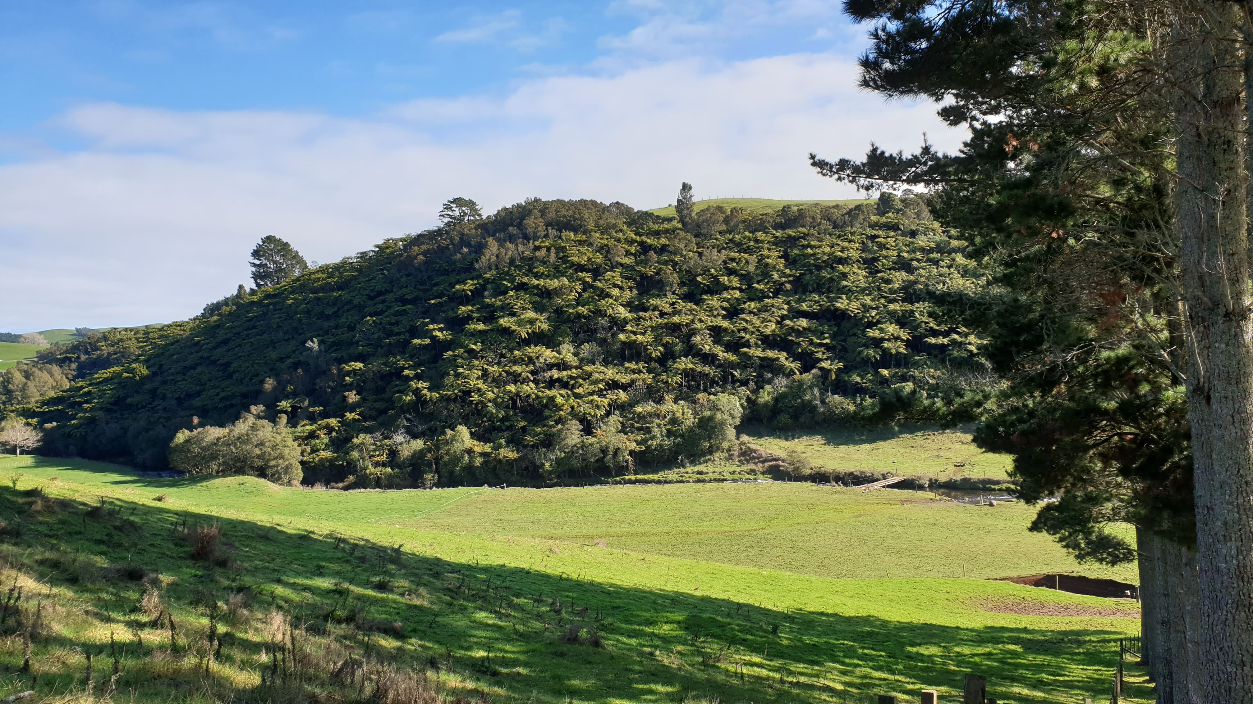
The solution approach begins with identifying the region's main rivers and understanding their hydrology using mapping and geoprocessing tools. After understanding the hydrography of the area and mapping the surface water extent river course through the building a hydrographic dataset, multiple image sources are used to map the historical land use and land cover surrounding the river.

1. Resources needed

Software

  • QGIS https://www.qgis.org/en/site 
  • TerraHidro 5 - Console applications https://www.dpi.inpe.br/terrahidro/doku.php
  • PostgreSQL https://www.postgresql.org
  • PostGIS Spatial Database System  https://postgis.net/
  • PgHydro extension for PostgreSQL/PostGIS http://pghydro.org/
  • PgHydro Plugin for QGIS https://plugins.qgis.org/plugins/PghydroTools/

Data

Forest And Buildings removed Copernicus DEM

Publications

see reference in the bibliography below.

2. Steps to the solution & status

Overivew

  1. Plot the Region of Interest (completed)
  2. Identify the region's main rivers and understand their hydrology (completed);
  3. Identify the region's potential flood areas using H.A.N.D.;
  4. Build a hydrography dataset (completed);
  5. Identify multiple image sources for land cover analysis (completed);
  6. Map the historical land use and land cover surrounding the river (in progress);

Step-by-step

1. Plot the Region of Interest (completed)

  1. Download and install QGIS to plot the KML files of the region of interest
Example KML plot of the strip of land of the Maori communtiy who submitted the challenge
Figure 1: Example KML plot of the strip of land of the Maori communtiy who submitted the challenge


2. Identify the region's main rivers and understand their hydrology (completed)

  1. Download the FABDEM data for the Region of Interest.
    FABDEM (Forest And Buildings removed Copernicus DEM) is a global elevation map that removes building and tree height biases from the Copernicus GLO 30 Digital Elevation Model (DEM) (https://data.bris.ac.uk/data/dataset/25wfy0f9ukoge2gs7a5mqpq2j7).
     
    A FEABDEM Digital Elevation Model of the Ngutunui region, New Zealand.
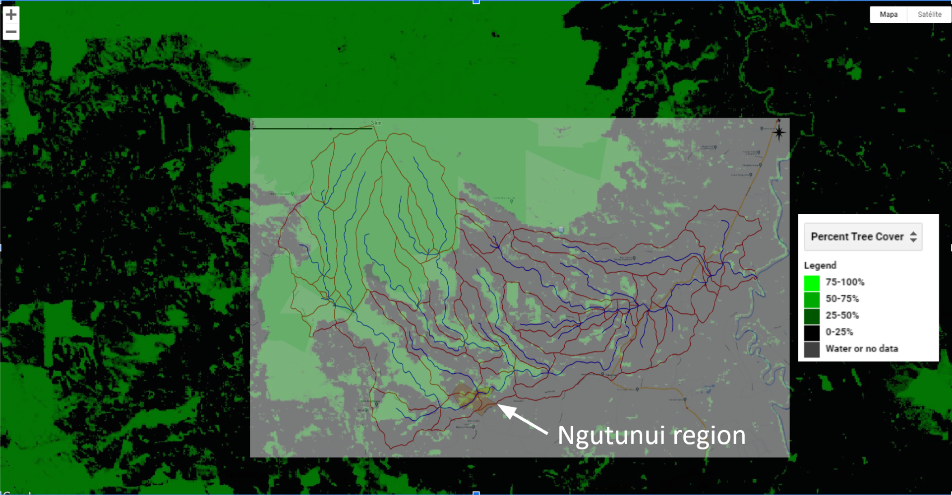
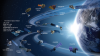
    Figure 2: A FEABDEM Digital Elevation Model of the Ngutunui region, New Zealand.

     
  2. Download and Install TerraHidro 5 - Console applications (https://www.dpi.inpe.br/terrahidro/doku.php) to extract the hydrograph products derived from the FABDEM to understand the hydrography setup of the area (Flow direction, flow accumulation and drainage lines and areas, H.A.N.D.).
     
    Flow direction in the Ngutunui region, New Zealand
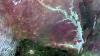
    Figure 3: Flow direction in the Ngutunui region, New Zealand
    Flow accumultation in the Ngutunui region, New Zealand
    Figure 4: Flow accumultation in the Ngutunui region, New Zealand
     
    Sintetetic drainage lines and areas
    Figure 5: Sintetic draingage lines and areas Ngutunui region, New Zealand


3. Identify the region's potential flood areas using H.A.N.D.

Building on Nobre et. al (2011) in which the HAND terrain model that "normalizes topography according to the local relative heights found along the drainage network, and in this way, presents the topology of the relative soil gravitational potentials, or local draining potentials" is introduced by the authors.

Height Above the Neaerest Drainage (HAND)in the Ngutunui reiong,
Figure 6: Height Above the Neaerest Drainage (HAND) in the Ngutunui region showng the areas for potential flooding in darker blue. In the current map this is in the bottom right quarter of the image.


4. Build a hydrography dataset (completed)

  1. Download and instal PostgreSQL/PostGIS Spatial Database System (https://www.postgresql.org/) (https://postgis.net/), PgHydro extension for PostgreSQL/PostGIS (http://pghydro.org/) and PgHydro Plugin for QGIS;(https://plugins.qgis.org/plugins/PghydroTools/).
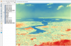
  2. Build the Hydrograph Dataset;(https://www.youtube.com/channel/UCgkCUQ-i72bBY41a1bhVWyw) using the Drainage Lines and Drainage Areas extracted from FABDEM;
  3. Information like drainage area, upstream area, drainage line length and distance to sea information are now available.
     
    Hydrography dataset of the Ngutunui region in New Zealand
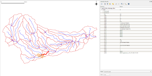
    Figure 7: Hydrography dataset of the Ngutunui region in New Zealand


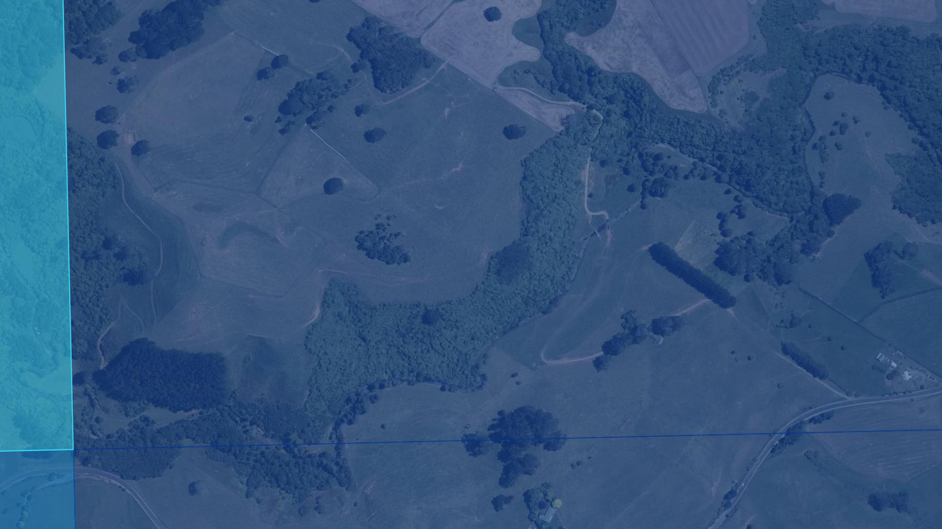
5. Identify multiple image sources for landing cover analysis (completed);

  1. To collect historic and high-resolution up-to-date imagery over the area, UNOOSA contacted the Land and Information New Zealand Data Service, which provided both historical aerial imagery and LIDAR data sources.
  2. Historic data for the relevant land patch can be accessed via the Retrolens New Zealand Service (https://retrolens.co.nz/Map/#/1784971.9859981549/5783474.532151884/1786387.2653498782/5784857.564632303/2193/12).
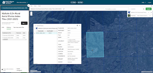
  3. Up-to-date aerial photos of the area can be accessed here at the New Zealand Data Service. Tile 503 and 603 are the ones of interest (https://data.linz.govt.nz/layer/112048-waikato-03m-rural-aerial-photos-index-tiles-2021-2023/history/).
  4. Relevant Landsat data are available from 1989. For the study area, Landsat 7 data is available from 2 July 1999, and Landsat 4 from 2 February 1989;
  5. Google Earth Engine Apps - Global Forest Change (https://google.earthengine.app/view/forest-change)

6. Map the historical land use and land cover surrounding the river (in progress);

Relevant publications
Related space-based solutions
Keywords (for the solution)
Climate Zone (addressed by the solution)
Habitat (addressed by the solution)
Region/Country (the solution was designed for, if any)
Relevant SDGs